Thursday, May 31, 2007
Four Corners
The Spruce Tree House was just a few hundreds yards down a steep but well maintained trail. These cliff dwellings were not as large as the ones at the Cliff Palace, but there was reconstructed kiva which Nick and I promptly climbed into. Darkness, sand in the air and the low ceiling created a rather claustrophobic atmosphere here. I could feel the sand in my mouth when we climbed back out.
A kiva is thought to have been a place of gathering for worship, and at least one can be found adjacent to most cliff dwellings and pithouses. Kivas were usually round, with the fire built in the middle of the room. The only way in and out was through a whole in the ceiling located directly above the fire. Thus anyone coming in or going out had to climb through the smoke. Each kiva also had another source of air for ventilation.
As we hiked down deeper into the Spruce Tree Canyon, we could tell we were getting closer to the water as progressively more bugs were attacking us right and left. At the lowest point of our hike the grass was growing tall and bright green all around the trail—a drastic change from the desert-like rim of the canyon. As we completed the loop and climbed out of the canyon we walked through a burned area of the mesa. Here most trees were bare and charred, and only small underbrush was green.
We made two more stops on our way out of the park. At the Far View Ruins, Nick and I climbed through a tiny door to look into a series of rooms built above ground and walked up the trail to see a dry reservoir.
Our second stop was at Park Point. A walk through very young woods just springing up after a fire led us to the edge of the cliff and some spectacular views of the Montezuma Valley and the La Plata Mountains.
The Wal-Mart in Cortez, CO was the only place I could find 100 ISO film. On our way out of Colorado we could not help but stop at the Four Corners. It is a definite tourist trap, but entirely worth the $3 per person entrance fee to be able to stand in 4 states all at the same time. The states that meet up at the Four Corners are Colorado, New Mexico, Utah and Arizona.
Small houses mostly in need of serious repair were sparsely scattered by the road. The combination of being in a desert like environment and seeing these poor living conditions created a sense of being in a foreign country. It reminded me of Honduras a little bit. Yet we were still in the United States, driving through the Indian Reservation.
We checked into our hotel in Kayenta, AZ in the early evening, and without bothering to unload the car drove over 20 miles to get our first glimpse of the Monument Valley.
Monument Valley is located on the border of Utah and Arizona, and is part of the Indian Reservation. The sun was getting ready to set when we arrived. As we slowly drove along the 18 mile unpaved scenic loop, vibrant reds and bloody oranges played on the rocks. It was both amazing and sad to see people living right next to these magnificent rock formations. Colorful laundry hung out to dry seemed incongruent with the grandeur of the landscape.
We stopped at many viewpoints along the loop, which took us over 2 hours to drive. The shadows were purple when we reached the Artists Point, and the darkness set in when we completed the loop. As I looked back something enormous was shining bright gold on the horizon. For a second I thought it was an outrageously enormous billboard still reflecting the last rays of sunlight, but it was the moon. An enormous orange moon was quickly rising above the park.
Wednesday, May 30, 2007
Mesa Verde National Park
We were staying at the Far View Lodge inside the park and it was absolutely beautiful. Our room had a little balcony with a magnificent view including La Plata Mountains. The copper sink, stone floors, Navajo style décor all exuded charm and coziness. The room also provided us with a small refrigerator, a priceless accommodation during our road trip. The Far View area of the park is at the elevation of eight thousand feet, so it was breezy and pleasantly cool.
Mesa Verde National Park is designated to preserve the works of the Anasazi people. The people have lived at Mesa Verde since about 600AD, but something forced them to start building their homes in the cliffs of the canyon around 1200. By 1300 the mesa, including the cliff dwellings, was completely abandoned. While there are many theories on the subject, what caused these people to build homes in hard to get to cliffs and then abandon them only a couple generations later remains to be a mystery.
We started the day with a guided tour of the Cliff Palace. From the viewing platform at the top of the cliff, the structures looked like a miniature little town, little houses built one on top of another. A steep paved path snaked down the cliff. The early people had to use much more difficult approaches to their houses. Up close the houses looked unusually well built. It was hard to believe that they were over 700 years old. The ranger leading our group offered his favorite theories to explain the mysteries of the cliff dwellings. I was surprised to learn that the houses originally were colorful and decorated with various patterns and paintings. We were able to see some examples of the painting on the inside walls of the tower. The way out of the Cliff Palace required climbing a series of 10-foot ladders.
After a brief break we headed for our guided tour of the Balcony House. The Balcony House was much harder to access than the Cliff Palace, requiring everyone to climb a 32-foot ladder.
Before taking us on the tour, the ranger spent more then a minute warning the group of the dangers involved in taking the tour with a heart condition and even described someone dieing on this tour. The ladder was indeed a bit intimidating, and I think it was nice that the park goes out of its way to warn the visitors of the risk. On one hand, I might argue that the warning was excessive when comparing this tour to some other hikes we did in other National Parks. On the other hand, the area of the tour is at elevation of over 6000 feet which does make any moving, hiking and especially climbing a lot more difficult.
Aside: Zion National Park should have a ranger stationed at all times at the Scout’s Lookout in Zion National Park warning people of the risks involved in climbing the trail to Angel’s Landing, and specifically relating the details of fatal incidents.
The Balcony House seemed like it would be even harder to get to then the Cliff Palace. A very narrow tunnel on the one side where the original entrance was would make the “house” an easily defensible place. We had to crawl through the tunnel on our way out.
Nick and I spent the afternoon driving around the Chapin Mesa stopping to look at some late pithouses and Pueblo ruins. Unfortunately we could not make it to the Wetherill Mesa because the road there was closed for repairs. After relaxing in our fabulous room and enjoying the view from the balcony, we headed to the Metate Room Restaurant at the Far View Lodge for a nice quite dinner. Tomorrow we will be heading to Monument Valley.
Tuesday, May 29, 2007
Moab, UT--Dinosaur Tracks
The Copper Ridge Sauropod Dinosaur Tracks site is about a mile drive along an unpaved road just north of Moab, UT. We had a little adventure finding the turn off the highway, but it is indeed very close.
The site did not seem to be too popular with the tourists. There must have been no more then 10 visitor groups who have signed the “guest book” in the last week. We walked about 100 yards up a trail and reached a sign describing the tracks, the dinosaurs and showing a photograph of one of the tracks at the site.
Nick and I walked out to the rocks beyond the sign and began our search for the promised footprints. I did not really know what I was looking for, so I was more or less pointlessly wondering about looking at various shapes of the rock under my feet. Nick definitely had a purpose. He was diligently pouring water over different depressions in the rock hoping to see the dinosaur paw imprint. But to no avail. Half an hour later we were still walking staring at the same rocks looking for the tracks.
I decided to take a little more interest in finding the tracks because I sensed that we would not leave the place without seeing the dinosaur tracks, and the idea of spending the rest of the evening there did not appeal so much to me. Nick and I decided to concentrate on the photo displayed on the sign and to search for the rocks in the photo in order to identify the location of the tracks.
To make the long story short, the tracks were located in front of the sign, not beyond it where we were so diligently searching. In other words, the tracks would be behind a person reading the sign. We essentially walked right over them when we approached the sign.
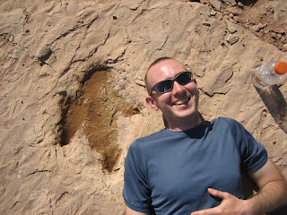
The sauropod tracks were enormous, but not so interesting in appearance because there was very little detail visible in the enormous holes in the ground. The raptor tracks, on the other hand, were fascinating. They clearly revealed the three separate “fingers” with claws at the end.
Nick’s rejoicing over finding the tracks had no end. He photographed them from all angles possible. He poured water in them to make their shape clearly visible. He stood in the tracks. He lay next to the tracks. He had me photograph him in various poses next to the tracks. When the thorough documentation of our visit to the dinosaur track site was over, Nick and I left the tracks to dry out in the sun and drove south out of Moab. Tonight our destination was Mesa Verde National Park in Colorado.
Biking in Moab, Utah
I admit I have not been on the bike in a few years. I do own a lovely yellow Gary Fischer mountain bike. Yes, I love my yellow bike. However, Nick and I have not gone biking since moving to Boston. We have many excuses—first not having a car, then being lazy about getting Nick’s bike fixed, not having a car again, etc… So when Nick suggested I try out my rented bike in the bike shop parking lot, I refused. Frankly I felt my knees starting to shake, and all the biker guys around definitely looked rather intimidating.
Now alone with Nick in this large rocky parking lot I mounted the bike with my knees still shaking. I did not forget how to ride the bike, but the thought of not only riding the bike, but also having to operate the breaks and the gears made the hairs on my back stand up.
The plan was to go to the Hurrah Pass. Nick and I started along the gravel road which ran slightly uphill along the cliff of the canyon. After a few turns, the road started sloping sharply downward descending into the canyon. My bike started gaining speed (with me on it). I did not feel in complete control of my bike in the first place, and now increasing speed, ever larger potholes in the road, tight switchbacks, and horrible noises the bike was making did not increase my confidence in my mountain biking abilities. A few seconds later and on the verge of tears I was walking my bike downhill through all those potholes, large rocks and switchbacks. As Minh used to say, “There is no shame in walking.”
Nick, who had to walk a little bit on the way up but passed me on the way down, was waiting for me at the bottom of the hill. As he handed me a bottle of Gatorade, he thoughtfully remarked that he has considered intermediate level biking trails but ended up choosing the Hurrah Pass trail because it was described as an easy trail suitable for families with little kids.
The rest of the ride towards the pass was much easier for me, and I think pure fun for Nick. I did discover that cow grates intended of course to keep cows out of the specific area also worked really well for keeping biking Helens out of the same areas. First time I came across one of these on my bike, I had to dismount and walk way around it. Luckily on the way back I was able to control my bike sufficiently so that I did not have to dismount, but I still slowly rode around the cow grate.
While biking we noticed two climbers scaling a vertical wall of the canyon. For me the coolest part of that was noticing two labs wagging their tails waiting for their owner on the ledge below.
We decided not to attempt biking all the way to the Hurrah Pass as the last 2 miles to the pass were going to be a continuous uphill, and therefore not as much fun. Instead we turned off onto a branching trail towards a creek and had lunch under a poplar tree.
The ride back seemed easier and went by faster, probably because most of it was a little downhill. Repeating another one of Minh’s “mottos” to myself, “Speed is your friend” I was able to dismount fewer times on the way back. I am also proud to say that I rode up the hill that I walked down only stopping once to take a break.
Overall we rode a little more then 12 miles in about 3 hours. I think if Nick and I could be combined into one biker we would do pretty well. Nick would speed through all the downhills and various obstacles, while I would push through the uphills. Regardless we enjoyed the ride and the scenery.
Monday, May 28, 2007
Arches National Park, Windows and Fiery Furnace
Our next adventure was the hike up to the Delicate Arch, one of the most popular hikes people do at the park. After a few switchbacks the trail led up a giant rock. From a distance the hikers looked like little ants climbing up this hill. Eventually the path leveled, and the Delicate Arch revealed itself just around the corner.
The best time to view the Delicate Arch is supposed to be at sunset, but even in the middle of the day when we got there it was a magnificent sight. Perched on the edge of a cliff, the arch turned out to be a lot bigger then I imagined it to be. Honestly I could not have imagined the real grandeur of many arches we saw without standing underneath them or seeing them in relation to people standing nearby. The enormity of these rock formations is hard to comprehend. The snow on the peaks of the La Sal Mountains shined in the distance behind the Delicate Arch.
After hiking to the Delicate Arch we took a break before a three hour and approximately 2.5 mile guided hike through the Fiery Furnace. We spent our time driving through the park, stopping at various pull outs to enjoy the views, and strolling around the Balanced Rock formation.
We decided to take a guided tour because the Fiery Furnace rocks form a maze of sorts that is very easy to get lost in. At 4 pm sharp we were standing at the Fiery Furnace viewpoint ready for our guided tour. We were part of a group of 25 people following a park ranger. On the hike we learned that apparently the mormon tea plant is of the ephedra family, and ring tail cats have been sighted regularly in the Devil’s Garden area of the park. The ranger also helped us through some of the more difficult parts of the trail.
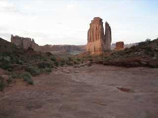
With just a couple hours of light left, we hiked half way up the Park Avenue trail and returned to the Courthouse rock formation when the sun was almost gone. This sunset was our first and last in the park for now, and it was sad to leave. Despite all the crowds the rock formations felt inspirational. We will have to return here again one day.
Sunday, May 27, 2007
Arches National Park, Devil's Garden
After the initial ascend into the park, we could see beautiful vistas opening up on both sides of the road. We were driving right next to beautiful red rock formations, and the snow covered peaks of the La Sal Mountains glistened in the distance.
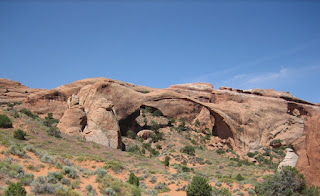
We drove to the Devil’s Garden area of the park and set off on a 7 mile loop hike. The first arch we saw was the Landscape Arch, apparently the longest arch in the world. After many rocks fell down from the arch in 1991, the path leading under it has been closed. One park ranger we talked to thought the Landscape Arch might collapse any time. As we continued down the trail, we saw several more arches, including one of my favorites—the Navajo Arch.
At one point we hiked over a relatively narrow ridge with views opening up into green valleys on both sides. The Double O Arch crowned the end of the trail. We took the primitive access trail leading through Fin Canyon back to the parking lot.
In the evening we visited Dead Horse Point during sunset and got a glimpse of the Mesa Arch in the Canyonlands right after the sun has set.
Saturday, May 26, 2007
Nevada to Utah
Finally we had lunch and left Las Vegas around 1pm aiming to reach Moab, UT in about 7 hours. The first chunk of the drive lay along I-15, which cuts across a corner of Arizona on its way from Nevada to Utah. We passed many beautiful rock formations--red pillars towering over the highway and multicolored ranges in the distance. We reached Moab, a very touristy town near Arches National Park, around 9pm.
Tuesday, May 15, 2007
Susie Baby
The first time I heard of it was when one winter morning our shuttle passed by Susie’s bus. Both vehicles stopped, and the drivers exchanged very happy-giddy greetings. Once the shuttle got going again, Victor, usually a very quiet man, would not stop smiling and repeating, “That’s my Susie.” Sneaking a peak at all of us, passengers, through his large rearview mirror, he kept nodding his head and saying, “That’s my Susie.” Victor says “Susie” with a slight Spanish accent. So the name sounds more like “Soosie”.
Today we experienced another encounter with Susie. This time the school bus stopped at an intersection to pick up the children. Victor stopped the shuttle about fifty yards away to give Susie plenty of room to turn. As we waited for the children to get on the bus, Victor was again expressing his joy on seeing Susie. “Soosie, ha, ha… Soosie, ha, ha, ha,” he kept laughingly saying. He was very pleased. Unfortunately today Susie did not stop the bus to say hello to Victor, but only gave him a big smile and waved. That seemed to have been plenty for Victor--he kept smiling at us in the rearview mirror all the way to work. I am sure if at all possible, Susie will stop and say hello to Victor and us next time.
Saturday, May 12, 2007
Lilacs
The first lilac blooms in Moscow showed up in the markets. Old ladies sold them by the subway stations. The lilacs in the country must have bloomed earlier than the ones in the city. There were always a few branches of blooming lilacs in a vase at my friend's birthday party around Cosmonautics Day. (We always looked for the "lucky" five petal flowers in the sea of the four petal ones.) But soon the Moscow lilacs would start blooming too, showing their bright whites and mild violets through the tender spring greenery.
It is now May, and Boston is finally experiencing lilacs in full bloom. Mid May is a bit late for lilacs to be still blooming, but it is Boston--the city that has no spring. Boston is the city where winter suddenly turns into summer, and summer equally suddenly becomes winter. Consequently just about everything, that usually blooms over the course of spring, in Boston blooms at the same time--tulips, daffodils, magnolias, plum trees, cherry trees, apple trees, dogwood trees, azalias and of course lilacs.
Every year the Arnold Arboretum holds a day long celebration for the lilacs. This year the Lilac Sunday was held today, on May 13th. Nick and I headed to the Arboretum on Saturday with the idea that we would get a glimse of the lilacs in full bloom and avoid the crowds. We got there as the sun was setting, and walked around until after sunset.
Wednesday, May 9, 2007
Бременские Музыканты
(Disclosure: Apologies to the "can't read Russian" folks.)
Из Бременских Музыкантов:
Разбойники (поют):
...
Завтра дальняя дорога
Выпадает королю.
У него деньжонок много,
А я денежки люблю.
...
Ой-ля-ля, Ой-ля-ля,
Завтра грабим короля!
...
Рассказчик:
Трубадур сразу понял что разбойники собираются ограбить короля.
Моя реакция:
Ну какой сообразительный!
По Следам Бременских Музыкантов:
Рассказчик:
Глупый король вручил генеальному сыщику обещенную королевскую награду, плачащую принцессу запер на ключ и строго на строго велел страже охранять все входы и выходы во дворце.
Моя реакция:
А что собственно еще этой страже делать кроме как "охранять все входы и выходы во дворце."
Sunday, May 6, 2007
James Joyce Ramble
This was indeed a well organized, very pleasant race. Eric and I both greatly enjoyed it. Unfortunately, the actors lack in any voice amplification. Thus, every time I passed one by, I could only hear a few words--never enough to grasp a phrase. I wish I could blame this unpleasantry on the extreme speed of my running. Alas, we all know it is not so. (Results of the race.)
No More Car
- being taught by Eric how to start the car on the uphill
- getting pulled over for excessive/inappropriate "blinking"
- driving my grandfather around Seattle
- listening to U2's "Achtung Baby" for months while driving South on I-495
- listening to Dave Matthews' "Two Step" while driving in snowy Walla Walla
- driving across the country, watching the car "turn" 100,000 miles near Chicago
Perhaps less than interesting numbers:
When I first set foot into my car, it was exactly 43,000 miles. Last time I saw it, the car was 107,877 miles.
Friday, May 4, 2007
Wally Schirra Died Thursday
Tuesday, May 1, 2007
Characters On the Train
I believe I felt the same today as Mr. Beebe did. As I was getting off the commuter train on my way to work, I noticed a young man with multiple large white blooms in his hair, arranged in the shape of a wreath. I first attributed the decoration to the spur of the moment giddy celebration of the arrival of spring and sunny weather. However, upon closer observation it looked like this was a well planned part of the young man's attire. The flowers were carefully held in place with hair pins.
By the way, the above quote does not appear in the book. Only a vague story involving violets, the Miss Alans and Mr. Emerson is briefly mentioned.