Our friend Ryan, who together with his girlfriend Talia, spent the 2nd week of our trip to Utah with us, also documented our adventures in his blog. I thought it would only be fair, if you had a chance to learn his side of the story:
(The titles to the links are also by Ryan)
Day Zero - In which the journey is conceived
Day One - In which departure is made with haste and the Grand Canyon lives up to its moniker
Day Two - In which canyon tree frogs lure the protagonists down the Kaibab trail
Day Three - In which the Bryce Amphitheatre plays host to a concert of Hoodoos
Day Four - In which the ancient Bristlecone Pine of Rainbow Point does not die
Day Five - In which snow lands in Bryce Canyon and Angels land in Zion
Day Six - In which the Narrows aren't too narrow, but too dark
Day Seven - In which Wall Street is obtained with the help of a bow-staff
Day Eight - In which commencement commences, and the journey decommences
Wednesday, June 20, 2007
Sunday, June 10, 2007
Leaving Las Vegas
We got a great night sleep, spent about 2 hours cleaning out the car, and repacking our belongings to make them airplane worthy again, and hung out with my relatives till early afternoon.
Around 2 or 3 pm we were driving down W. Sahara Avenue towards the strip. You might remember the left over firewood we "threw" in the car when we were about to leave our campsite in the Grand Canyon National Park. It just happened so that this very firewood was still happily riding in our car. With only a few hours remaining till we had to return our faithful rental car, we puzzled over the proper way to get rid of the firewood. My suggestion to toss it into a random dumpster we passed between various strip malls was firmly rejected under the pretext that unauthorized dumping is illegal. We reached Las Vegas Boulevard still in possession of the firewood.
Our plan was to visit a few more hotels along the strip, grab an early dinner, and head to the airport. We started at the Paris Hotel, and walked through the Treasure Island, the Venetian and a couple others. We stopped at the Bellagio once again to see some of Picasso's Ceramics on display at the Bellagio Gallery of Fine Art. The exhibit was small but intriguing, and the audio guide did not disappoint providing us with bits of curious information about Picasso and his plates, owls and jars.
Back at the Paris Hotel, we grabbed a dinner and some fancy dessert, and drove off to the airport. We arrived at the car return, still with the firewood in tow. At this point, Nick confidently walked over to a garbage can, lifted off the nice cover, and stuffed the firewood into it, carefully replacing the cover. He was not caught in the act.
We flew out of Las Vegas before midnight, thus ending our wonderful adventurous vacation.
Saturday, June 9, 2007
From Zion Back To Las Vegas
 First thing in the morning, we went out to the Mean Bean Coffee House, a small coffee shop in Springdale, and got a muffin and a cup of hot chocolate. The muffin was for me, and the hot chocolate was for Nick, but Nick and I practically fought over this drink--definitely the best hot chocolate I have ever had. Today we would be heading to Las Vegas, but we still had a few stops to make in the Zion National Park before leaving.
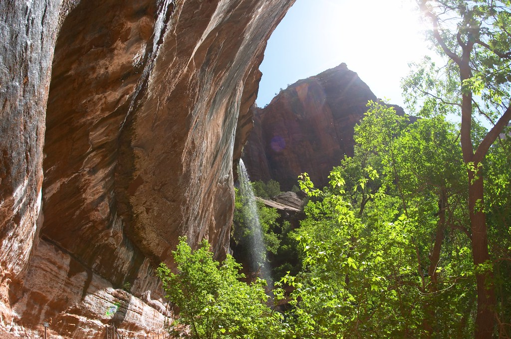
First we headed to the Weeping Rock. A short walk away from the main road took us to a beautiful magic place where water was coming out of the rock. Someone told us that it takes the water 2000 years to travel from the top surface of the cliffs through the sandstone to the impermeable shale where it is forced back out. The constantly dripping water and abundant moisture created a beautiful hanging garden. There was perfect stillness around us with nothing but the sound of dripping water.
 Next we headed to the Emerald Pools. As the trail led uphill along the side of the canyon, we enjoyed beautiful views of the cliffs around us. A tall narrow waterfall came down into the first pool. Walking along the wall, we walked behind it, and even enjoyed a little rainbow. The third pool was the largest and probably the deepest. The most majestic of the three, it was hidden away between absolutely vertical red cliffs, while its truely emerald waters reflected the lush greenery around its steep banks.
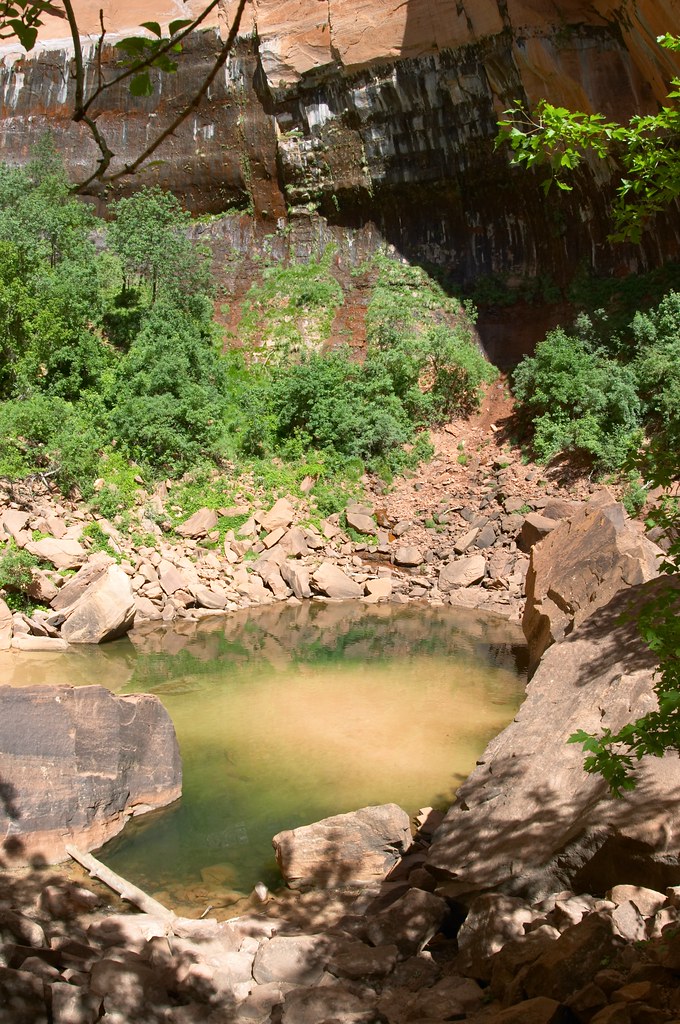


After a brief stop at the Court of the Patriarchs to admire three large peaks named after Abraham, Isaac, and Jacob, we took the shuttle back to the Visitor’s Center. Here we picked up the horrid news about 2 people who have died while hiking the Angels Landing trail since we hiked it on Wednesday. After a short postcard shopping spree at the gift shop we said goodbye to Ryan and Talia, and they headed to the more remote and much less visited part of the Zion National Park, the Kolob Canyons, for one more hike, before driving back to LA.
 Nick and I drove back to the park’s East Entrance. Our car climbed out of the canyon and back through the tunnel. Now we were almost as high as the rim of the canyon. Here the rocks bore amazing patterns on their surfaces and were a lot paler in color—apparently the minerals slowly seep down and out of these rocks with age, causing the tops of the peaks to slowly lose their bright color. We did a short hike among these round “scratched” looking rock tops and admired the Checkerboard Mesa Rock.
 Now it was time for us to leave Zion for good, and headed back to Las Vegas. Once again we stopped to inspect some dinosaur tracks at St. George Dinosaur Discovery Site at Johnson Farm in St. George, Utah. The tracks here were numerous and extremely well preserved, including such rarities as some skin impressions and dinosaur swimtracks.
It was after 7pm when we plunged back into maddening civilization and reached our hotel in Las Vegas. Tonight was our one chance to see the strip at night, so we took a shuttle from our hotel to Mandalay Bay and joined the curious crowds of tourists gawking away at the Las Vegas Boulevard.
We quickly learned that pretty much all the casinos in different hotels looked the same, with a distinct odor mixture of cigar smoke, perfume, and alcohol, perfect to inflict a headache. We walked into Bellagio and were swapped away by their amazing flower arrangements everywhere and even grander flower displays. After a nice dinner in one of the restaurants, Nick and I watched the fountains--perfect coordination of music, water and lights. Happy and tired, we decided to call it a night, and caught the shuttle from Mandalay Bay back to our hotel.
Friday, June 8, 2007
The Narrows Hike
The day of THE hike has arrived. We were to leave civilization behind and hike 16 miles through the slot canyon of the Virgin River. Oh boy, were we excited! And a little scared, some of us more then others.
 After a terrible breakfast of very stale and super expensive muffins (Ryan and Talia were smarter and went for the breakfast buffet at the Lodge Dining Room), Nick and I drove out to the Zion Outdoor Adventure store where we were equipped with proper footwear (for walking through the river), dry bags (if you fall in the river, you want your sleeping bag to stay dry), and walking sticks. The four of us climbed into the van, which after driving for over an hour, partially on unpaved roads, eventually dropped us off in what appeared to be the middle of nowhere. The driver pointed to a dirt road on the side, told us to follow it, and drove off which my camera which I forgot on the floor of the van.
 We followed the unpaved road until we saw the river—the headwaters of the Virgin River. With great enthusiasm we started walking down the river. For some of us, me for example, the enthusiasm, not particularly high in the first place and already greatly damaged by my missing camera, was fading rapidly. Walking in the river was hard, I was slow and very far behind the others, and worst of all, I was getting annoyed.
In preparation for this hike we got lectured multiple times on the importance of preserving the environment and leaving everything the way we found it. The instructions were not to walk on any plants outside of the river. So here I was, struggling through admittedly the easiest part of the river, while all around me cows and farmers alike were destroying the vegetation, the natural river banks and in places even altering the flow of the river. This did not seem fair at all, and I felt cheated.
Nick and I did not want to hold up our friends with my very slow walking, so we decided that they should go ahead without waiting for us, and we would meet at our designated campsite (#6). After struggling through the water for over two hours, Nick and I decided to break for lunch.
Sitting on the muddy riverbank munching on our peanut butter and jam sandwiches we worried about making it to our campsite by dark. However slow, we have been walking for awhile, but there was still no sign of the canyon, and the pastures were surrounding us. Worried and pressured by my whining Nick decided to look at his map!
According to the map, we were supposed to walk on the unpaved road until we reached the river, which we did, then CROSS the river, which we did NOT do, and continue on this road for about an hour until the road ended. Clearly the road ran in a fairly straight line, while the North Fork of the Virgin River was snaking and zigzagging back and forth through the pastures. Since we could see the road from where we were having lunch, it was obvious that geographically we were still in the first hour of the hike, even though we have been traveling (or struggling) for over two hours already. Panic quickly set in.
 We swallowed the rest of our lunch, jumped out of the water and trotted down this dirt road, concentrating on whether or not we could make it to the campsite before dark. Interestingly the road was covered with footsteps of people obviously wearing the same exact shoes as we were. We finally were going the right way. About 20 minutes later, we reached the end of the road, and climbed back into the river. Now we were pushing ourselves to go as fast as physically possible. Actually to be honest, I was pushing myself to walk in the river as fast as physically possible, while Nick walked at his normal pace waiting for me to catch up at river bends.
Quickly the banks of the river grew higher and moved closer together. Soon we were in the Narrows. The red, silver and black of the river walls shined in the sun, and blind arches looked down at us. In a few hours we reached the 12-foot water fall, and the first designated campsite soon afterwards. We now began to relax our pace as it was becoming clear that we should be able to get to our campsite before dark set in. Instead we were beginning to wonder how long it had been since our friends reached our campsite, and how they were doing without the water filter all this time.


 While sunlight still played at the canyon rim, it no longer reached down to the bottom, and we were walking in the dusk. We reached a really narrow part of the canyon where the walls were of black color, making it seem even darker. This place was eerie with darkened faces coming out of the rocks in silent screams.
I remember deep green pools of water, and the bright fresh greens of the maples reflecting in the river. Unfortunately, I do not remember very much of the hike, because I was putting so much effort into trying to walk very fast. Hopefully one day we can hike the route a bit slower.
 We reached our campsite a little before 8pm, and to our great surprise our Ryan and Talia were not yet there. Their absence could only mean that we passed them when we walked on the dirt road. Their absence presented a serious problem since they were not carrying enough potable water to last them through the day, and we had both the water filter and the iodine pills. The possibility that they would be waiting for us somewhere up the river made matters even worse. However, the darkness was coming soon, and it would have been much slower to walk up the river, so Nick and I decided that all we could do was wait for them.
As the sun was setting beyond the walls of the Narrows, we laid our bright orange waterproof bags on the rocks and put up a flashlight pointing toward the campsite number to make it more visible. Our campsite was just South of the Kolob Creek, which for some reason was completely dry.  The sun still has not reached the bottom of the canyon when we continued our hike down the river. The air was still chilly making walking in the river water a little less pleasant, but the canyon walls shimmering in morning light made up for this small inconvenience.
Unfortunately it did not take us long to reach the Big Spring water falls. The Big Spring pours out of the face of the rocks above the river. This is also the point up to which the day hikers are allowed to go when traveling up the river. We left the wilderness behind, and now were surrounded by people bathing, and tanning on the rocks.
 Not having gotten real meals recently was starting to show, so Nick and I decided to use Ryan’s little stove to have a nice warm meal, and let Ryan and Talia go ahead. The expected meal of mushrooms and rice turned to me a mushroom and rice soup, which was a bit disappointing, but it was still rather filling. The day hikers walking by us gave us strange looks wondering why the heck we were making a hot lunch in the high noon, but what did we care.
 With our strengths replenished, and our moods significantly improved, we continued down the river. We passed the famous Wall Street, where the walls of the Canyon are only a few feet apart. Several springs have joined the river by now, and it was deeper and faster in most places.
We could tell how close we were getting to the end of the canyon by assessing the progressive lack of correct equipment in the people hiking up the river. We knew we were almost there, when we spotted a heavily pregnant woman hiking through the river. I was glad we were done, but at the same time I was sad. I wish I could have gone without worrying and rushing. I wish I could have taken more time to look around. Leaving the river did not only signify the end of the Narrows hike, but it was also the last real hike of our vacation.
We took the shuttle from the Temple of Sinawava, out of the park, and to the Outdoor Adventure store in Springdale to return our equipment. My camera was waiting there for me in its rented dry bag, which it now did not need.
All four of us had a plentiful meal in a Chinese restaurant in Springdale, and Talia and Ryan went off to bed soon after. Instead of doing the same, I convinced Nick that we are in desperate need of some ice cream. Since all the ice cream places in town already closed at a terribly late hour of 10pm, we grabbed a Hazen-Daz bar and an ice cream sandwich at a gas station, reminisced about a similar situation in Iowa 2 years ago and could not be happier.
 After a terrible breakfast of very stale and super expensive muffins (Ryan and Talia were smarter and went for the breakfast buffet at the Lodge Dining Room), Nick and I drove out to the Zion Outdoor Adventure store where we were equipped with proper footwear (for walking through the river), dry bags (if you fall in the river, you want your sleeping bag to stay dry), and walking sticks. The four of us climbed into the van, which after driving for over an hour, partially on unpaved roads, eventually dropped us off in what appeared to be the middle of nowhere. The driver pointed to a dirt road on the side, told us to follow it, and drove off which my camera which I forgot on the floor of the van.
 We followed the unpaved road until we saw the river—the headwaters of the Virgin River. With great enthusiasm we started walking down the river. For some of us, me for example, the enthusiasm, not particularly high in the first place and already greatly damaged by my missing camera, was fading rapidly. Walking in the river was hard, I was slow and very far behind the others, and worst of all, I was getting annoyed.
In preparation for this hike we got lectured multiple times on the importance of preserving the environment and leaving everything the way we found it. The instructions were not to walk on any plants outside of the river. So here I was, struggling through admittedly the easiest part of the river, while all around me cows and farmers alike were destroying the vegetation, the natural river banks and in places even altering the flow of the river. This did not seem fair at all, and I felt cheated.
Nick and I did not want to hold up our friends with my very slow walking, so we decided that they should go ahead without waiting for us, and we would meet at our designated campsite (#6). After struggling through the water for over two hours, Nick and I decided to break for lunch.
Sitting on the muddy riverbank munching on our peanut butter and jam sandwiches we worried about making it to our campsite by dark. However slow, we have been walking for awhile, but there was still no sign of the canyon, and the pastures were surrounding us. Worried and pressured by my whining Nick decided to look at his map!
According to the map, we were supposed to walk on the unpaved road until we reached the river, which we did, then CROSS the river, which we did NOT do, and continue on this road for about an hour until the road ended. Clearly the road ran in a fairly straight line, while the North Fork of the Virgin River was snaking and zigzagging back and forth through the pastures. Since we could see the road from where we were having lunch, it was obvious that geographically we were still in the first hour of the hike, even though we have been traveling (or struggling) for over two hours already. Panic quickly set in.
 We swallowed the rest of our lunch, jumped out of the water and trotted down this dirt road, concentrating on whether or not we could make it to the campsite before dark. Interestingly the road was covered with footsteps of people obviously wearing the same exact shoes as we were. We finally were going the right way. About 20 minutes later, we reached the end of the road, and climbed back into the river. Now we were pushing ourselves to go as fast as physically possible. Actually to be honest, I was pushing myself to walk in the river as fast as physically possible, while Nick walked at his normal pace waiting for me to catch up at river bends.
Quickly the banks of the river grew higher and moved closer together. Soon we were in the Narrows. The red, silver and black of the river walls shined in the sun, and blind arches looked down at us. In a few hours we reached the 12-foot water fall, and the first designated campsite soon afterwards. We now began to relax our pace as it was becoming clear that we should be able to get to our campsite before dark set in. Instead we were beginning to wonder how long it had been since our friends reached our campsite, and how they were doing without the water filter all this time.


 While sunlight still played at the canyon rim, it no longer reached down to the bottom, and we were walking in the dusk. We reached a really narrow part of the canyon where the walls were of black color, making it seem even darker. This place was eerie with darkened faces coming out of the rocks in silent screams.
I remember deep green pools of water, and the bright fresh greens of the maples reflecting in the river. Unfortunately, I do not remember very much of the hike, because I was putting so much effort into trying to walk very fast. Hopefully one day we can hike the route a bit slower.
 We reached our campsite a little before 8pm, and to our great surprise our Ryan and Talia were not yet there. Their absence could only mean that we passed them when we walked on the dirt road. Their absence presented a serious problem since they were not carrying enough potable water to last them through the day, and we had both the water filter and the iodine pills. The possibility that they would be waiting for us somewhere up the river made matters even worse. However, the darkness was coming soon, and it would have been much slower to walk up the river, so Nick and I decided that all we could do was wait for them.
As the sun was setting beyond the walls of the Narrows, we laid our bright orange waterproof bags on the rocks and put up a flashlight pointing toward the campsite number to make it more visible. Our campsite was just South of the Kolob Creek, which for some reason was completely dry.
By 9:30pm the darkness was complete, and we gave up. Surely no sane person could be still hiking the river in the dark. We hoped that they found a safe place to camp. Perhaps they asked hikers up the river to share their campsite, since most campsites were designed for more then one tent, and none that we passed were full. Perhaps they asked these same hikers to use their water filter. We knew there were only 8 people camping up the river from us, but we were still hopeful.
Gone were our hopes for a fun camp out in the canyon. We ate up the tuna packets we carried, supplementing them with some gummy bears and granola mix, and crawled into our tent for the night. We could hear something falling down around us. It scared me since whatever it was sounded like little rocks. A little tent was not likely to protect us well in case of a rock fall. Thankfully I was soon sound asleep.
We woke up around 6:30am. The morning felt gray, cold and damp making it hard to get out of our sleeping bags. Slowly we started moving again, washing up, munching on granola mix and Balance bars for breakfast. We only had about 7 miles to cover today and we were not in any rush to leave. We were hoping Ryan and Talia would still show up, catching up with us.
 Around 7:30 Nick spotted Talia and then Ryan walking down the river. What a joyous occasion that was. We were really happy to see them alive and well. Experiences of the previous day were told time and time again. Ryan and Talia kept walking down the river till 9:45pm the night before—well after Nick and I decided that no one could possibly be walking the river in this complete darkness. They pitched a tent on a tiny piece of dry land only half an hour walk from our campsite, and boiled river water for 10 minutes so that they could have drinking water.
 The sun still has not reached the bottom of the canyon when we continued our hike down the river. The air was still chilly making walking in the river water a little less pleasant, but the canyon walls shimmering in morning light made up for this small inconvenience.
Unfortunately it did not take us long to reach the Big Spring water falls. The Big Spring pours out of the face of the rocks above the river. This is also the point up to which the day hikers are allowed to go when traveling up the river. We left the wilderness behind, and now were surrounded by people bathing, and tanning on the rocks.
 Not having gotten real meals recently was starting to show, so Nick and I decided to use Ryan’s little stove to have a nice warm meal, and let Ryan and Talia go ahead. The expected meal of mushrooms and rice turned to me a mushroom and rice soup, which was a bit disappointing, but it was still rather filling. The day hikers walking by us gave us strange looks wondering why the heck we were making a hot lunch in the high noon, but what did we care.
 With our strengths replenished, and our moods significantly improved, we continued down the river. We passed the famous Wall Street, where the walls of the Canyon are only a few feet apart. Several springs have joined the river by now, and it was deeper and faster in most places.
We could tell how close we were getting to the end of the canyon by assessing the progressive lack of correct equipment in the people hiking up the river. We knew we were almost there, when we spotted a heavily pregnant woman hiking through the river. I was glad we were done, but at the same time I was sad. I wish I could have gone without worrying and rushing. I wish I could have taken more time to look around. Leaving the river did not only signify the end of the Narrows hike, but it was also the last real hike of our vacation.
We took the shuttle from the Temple of Sinawava, out of the park, and to the Outdoor Adventure store in Springdale to return our equipment. My camera was waiting there for me in its rented dry bag, which it now did not need.
All four of us had a plentiful meal in a Chinese restaurant in Springdale, and Talia and Ryan went off to bed soon after. Instead of doing the same, I convinced Nick that we are in desperate need of some ice cream. Since all the ice cream places in town already closed at a terribly late hour of 10pm, we grabbed a Hazen-Daz bar and an ice cream sandwich at a gas station, reminisced about a similar situation in Iowa 2 years ago and could not be happier.
Wednesday, June 6, 2007
Snow, Angels Landing in Zion National Park

 We started the day with a healthy breakfast of all-you-can-eat pancakes at a diner across the street from the inn. The weather was rather miserable, cold, gray and rainy. After breakfast, we left Tropic, driving back on Route 12. Our destination was the last park on our trip—Zion National Park. The rain changed to snow, and winter wonderland has arrived. The snow was falling heavy, staying on the ground, on cars, and even sticking to the road.
 We decided to make one more stop at the Bryce Canyon National Park for a chance to see hoodoos covered in snow. We drove out to the now familiar Sunset Point and rushed up to the rim. The snow was lying in the grass, stuck to the needles of the pine trees, but to our huge disappointment the hoodoos stood bare. In a few minutes the sun was shining brightly through the crispy air, and we continued on our planned route.
 Zion National Park is different from all other parks we have visited in that it requires visitors to use the park shuttle system to get around the park. The main area of the park is the bottom of the canyon formed by the Virgin River. With vertical walls surrounding the area is limited. As the number of park visitors grew, the canyon has become the perpetual traffic jam and a parking nightmare. The great number of vehicles also seriously affected the air quality. Today everyone except for those staying at the Lodge is required to park by the Visitor’s Center and take the shuttle from there. The nearby town of Springdale also has a free shuttle bussing people between any point on the town’s main street to the Visitor’s Center.
Nick and I arrived at Zion after a nice journey of only a couple of hours, and headed straight for the Visitors Center. We drove into the park from the East Entrance. From here, we had to travel 13 miles further to reach the Visitor's Center. The rock formations surrounding us were pale gray and had amazingly regular beautiful patterns as if etched into them.
The road led us into a tunnel, which was so narrow that it has to be closed to allow taller vehicles such as RVs or tour buses to pass, because they have to travel in the middle of the road to get enough clearance. The tunnel felt dark, cold, narrow and very claustrophobic. Occasional windows on the side blinded us with sunlight and glimpses of magnificent views, but there is no stopping here. According to Nick, the windows were created first and provided the access to build the tunnel inside the rock. Beyond the tunnel, the road descended steeply into the canyon.
We had business to take care of at the Visitor's Center since all four of us were going on a two-day backcountry hike on Thursday. We got our permit, poop bags, registered our vehicles, and once Ryan and Talia arrived, watched a video on what to do and not to do.
We planned to hike the Narrows. This is a 16 mile, two-day hike through the slot canyon of the Virgin River. The hike starts by the headwaters of the North Fork of the Virgin River outside the park, and follows the river through the canyon. Only 50 people a day are allowed to do the hike, permits are required, and the park assigns each group a specific camping spot. Camping spots are spread out along the river, and imply a clearing a little higher then the river to increase chances of hiker survival in case of flash flooding.
Each of us was worried about this backcountry adventure in his or her own way. Walking in the river, being cold, carrying too much weight or pooping into a bag—these were some of the concerns. Leaving the Visitors’ Center we made a trip to Springdale to check on some of the equipment we were to rent the next morning. Now we were ready to start enjoying Zion.
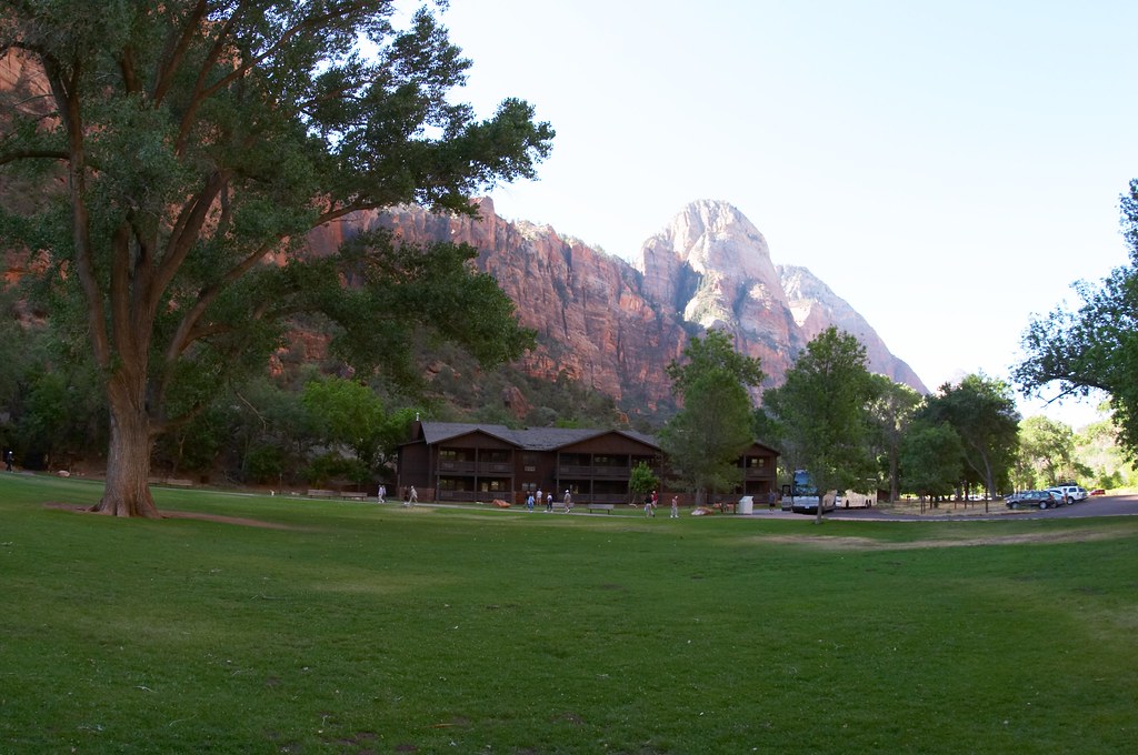 We made our way into the park and checked into the Lodge. The location was idyllic. “Happily situated” at the bottom of one side of the canyon, the lodge provided great views of the red walls of the other side of the canyon. A large lawn in the front supplied a perfect place for the visitors to relax while enjoying the beautiful surroundings. The hotel room itself did not impress me nearly as much. Dark, unattractive and not all that clean the room could definitely be improved, especially for the price.
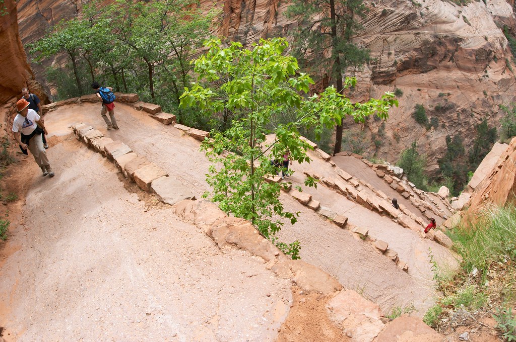 With a few hours of daylight still left, we headed out to do one of the most popular hikes in Zion—the Angels Landing. The trail began only one bus stop away from the lodge, and quickly climbed up towards the top of the rim. Though rather steep, the trail was wide and paved. As we zigzagged along the face of the cliff, the canyon bottom dipped below us. After walking up exactly 21 short switchbacks called Walters Wiggles, we reached Scout’s Lookout Point.
The trail to Angels Landing is about two and a quater miles one way. Having reached Scout’s Lookout Point, we were only about half a mile away from the goal, but what a half a mile that was. Nick decided not to proceed to Angels Landing, and we left our packs with him, which turned out to be a blessing.
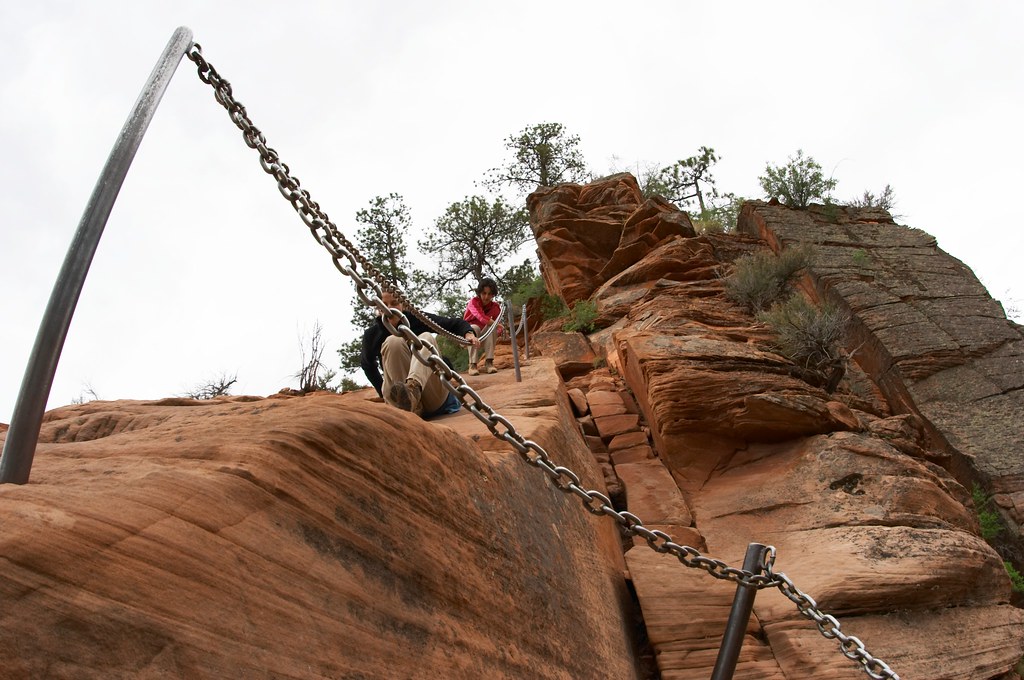
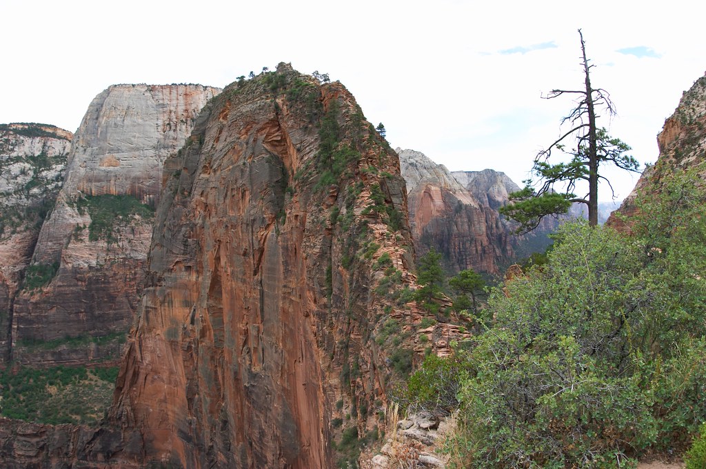 The three of us continued on the trail. During the first section of the climb we were on the side of the rock, and the ground sloped down sharply only on one side of the path. I tightly held on to the heavy iron chain drilled into the rock and tried not to look down. I thought we were there, when we reached the other side of the rock and stood on some flat ground. I was wrong. Directly in front me, the steep narrow ridge continued up, and somewhere at the very top I saw ant like people "crawling" along it. I felt dizzy from looking at them. However, the path in front of me was still tolerable. So determined not to turn around until I had to, I followed Ryan and Talia up the cliff.
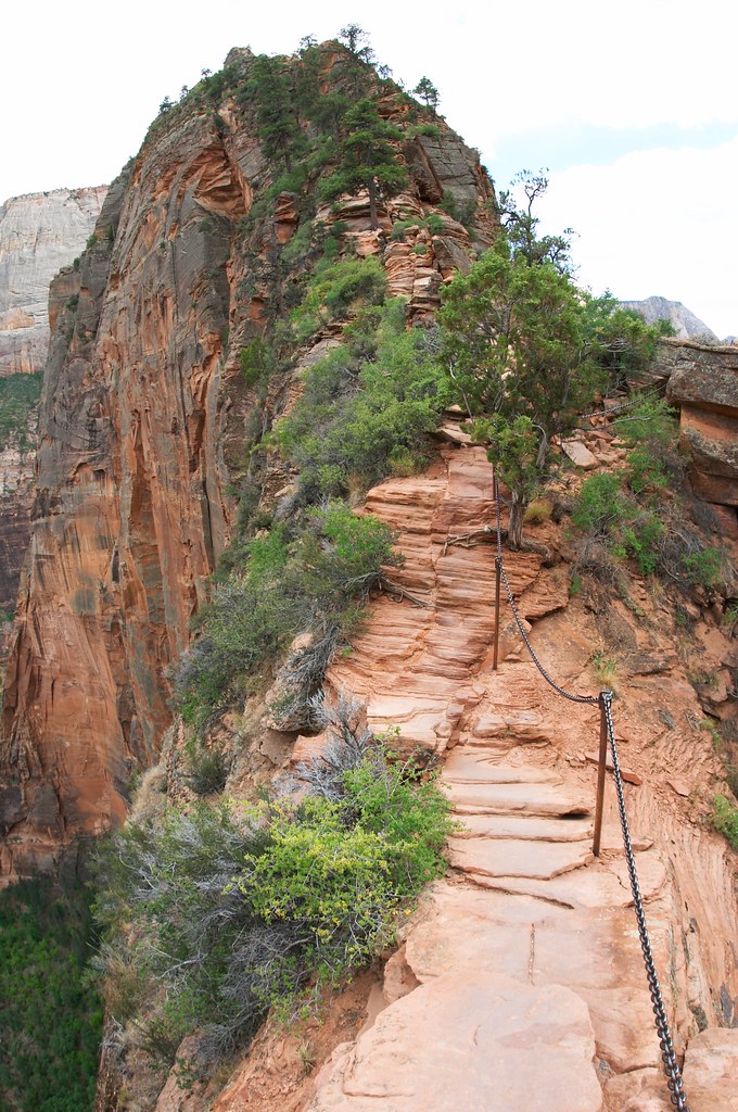 A lot of time the “trail” was only a couple feet wide, and dropped off over a thousand feet on either side. The climb itself was not at all technical, just frightening in that mortal kind of way. Several times there were people coming down from the top with whom we had to share the path. I thought we were lucky going up this trail in the evening on a weekday. A small crowd and a couple of impatient hikers on this trail could easily lead to a disaster. One guy passed us wearing Tevas, eating watermelon, and walking on the very edge of the path not bothering to wait until we moved over to let him pass.
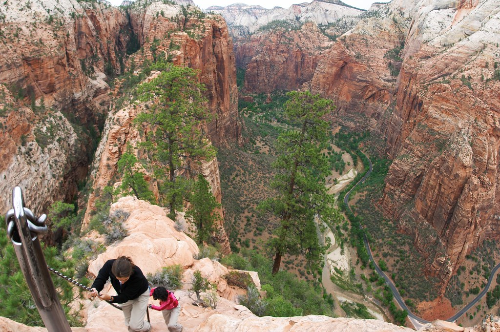 Talia was making interesting gargling sounds, which were apparently the result of a Yoga breathing technique used to keep one’s spirits up. I tried to mimic the breathing technique—I certainly needed to raise my spirits, but the noises coming out of me mostly resembled loud growling. Soon Talia and I were growling together pretending to be mountain lions. Mountain lines, you see, have no problems climbing cliffs like the one we were on right now. Our species of mountain lions were also more then partial to the chains embedded in the cliff.
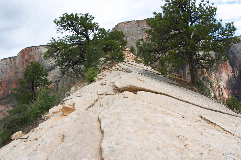 The vertical climb ended just as abruptly as it started, at a small platform. Once again informed that this was “not it”, I did not want to continue—the path to the spot actually called Angels Landing lay along the top of this narrow ridge we just climbed. But a hiker about to descend the cliff wisely pointed out that if I made it this far, I should have no problem continuing. Adrenaline pumping, we continued, navigating around some strong pine trees growing right in the middle of the ridge.
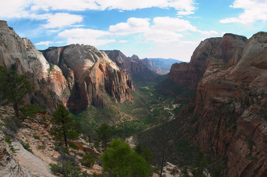 The cliff we have just climbed stands a bit forward of the other cliffs forming the rim. Angels Landing is right on the tip of the cliff creating the feeling that it is hanging over the canyon. The spot was given its heavenly name by a group of hikers passing through the canyon in 1916, who thought that only angels could ever land on the spot. The reward for the precarious climb is a 360 degree view of the Zion canyon.
When we reached Angels Landing, the setting sun was coming in and out of the clouds, playing on the cliff faces of the canyon and lighting up the skies. The ribbon of the road snaked below with miniscule buses barely gliding along. We were on top of the world.
 On our way down Talia and I raved about the lovely prairie dog rumps which are perfect for sliding downhill. We followed the philosophy of lowering our center of gravity to decrease our chances of losing balance. Even though we had to look down during our descend I found it a lot less frightening, perhaps because now there was no unknowns and no anticipation. Soon we reached Scout’s Lookout Point where Nick has been waiting for us for over 2 hours.
Vladimir Visotsky wrote several songs about climbing the mountains. Of course he was writing about actual mountain climbing and much taller mountains, but I think his words still apply to our case. I am about not only to translate but also to paraphrase, so please bare with me. In one song titled “Saying Goodbye to the Mountains” he wrote, “we descend because there is no other way; …even gods descended down to earth.” In another song called “The Summit” he wrote, “The whole world in a palm. You are happy, and speechless, and only a little jealous of the others who are yet to climb the peak.”
 Our walk back down into the canyon was fast and animated by retelling all the details of the climb. We walked to the Lodge, changed and went out to Springdale for a nice sumptuous meal, probably our last real meal in the next 48 hours.
Back at the hotel room, which all 4 of us were sharing that night, rapid packing began. We were packing for our 2 day hike through the Narrows. The men discussed such crucial points as the number of socks, pots, and water filters to bring, and how much the socks really weigh. While I use the word “important” here sarcastically, experience would show that some of these things actually were important. The resolution at the end of the night was one water filter carried by Nick, 2 pots carried by Nick and Ryan, and any number of socks carried by the sock owner. I was glad when we were finally done and could go to sleep.
Tuesday, June 5, 2007
Hiking in Bryce Canyon
I was up at 4:30 in the morning, and we were all packed into the car ready to go at 5:35am. Nick of course could have stayed behind and joined us later, but the plan was to start hiking right after sunrise, when the temperatures were still low, the people were few, and the lighting ideal for photography. Nick was not going to miss the hiking, so here he was, reluctantly awake and going to see the sunrise.
 We drove to the Sunset Point and followed the trail to the Sunrise Point. While I could not call it a crowd, we were certainly not the only ones crazy enough to get up so early.
  The view point was full of people, many with their tripods all ready to go. The sun was not up yet, but they were already clicking away. I can make fun of them of course, but in the end I pulled out my own tripod and began clicking away as well.
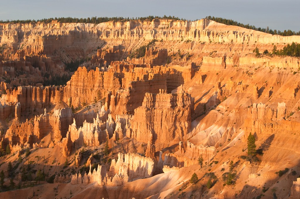
The rising sun painted the Amphitheater bright orange, and the hoodoos’ white tops shined brightly against the red orange rocks. The clicking intensified and then slowly died down. Most of these photographers headed to their hotels for a meal and a nap. Not us. We made a pit stop at the Bryce Canyon Lodge, and then were back at the Sunrise Point to start our “double trail” hike. We walked down the Navajo Loop Trail towards Wall Street.
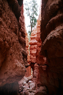 During our trip we have discovered that many parks have their own Wall Streets. The common feature seems to be massive and tall walls rising above the trail. The Wall Street at Bryce Canyon was our first close encounter with the hoodoos and it did not disappoint. The trail snaked down at a very steep angle while the hoodoos rose higher and moved in close on us. When the walls were no more then 3 yards we knew we have reached Wall Street.
 Unfortunately we could not continue down the Navajo Loop Trail because a rock fall has blocked the trail in May 2006, and the park rangers have not yet cleared it. We have spent a couple minutes debating whether not to climb over the rock, but the law-abiding citizen in every one of us spoke against it. Since Navajo trail is really a loop, we went back to the top and this time followed the other part of the trail, which led us past the famous Thor’s Hammer formation.
Again instead of us peering down on the hoodoos from the top, the hoodoos were now looking down at us as we found our way between them. The occasional tall pines growing around the trail seemed greener against the orange rock. Occasional dead trees had no place to fall in the narrow corridors between the hoodoos. So they remained vertical leaning against the rock walls surrounding them.
 We continued down the Navajo Loop Trail until we reached the same rock fall but from the other side. Three older gentlemen with well pronounced cowboy attitude were climbing over rocks from the other side. We followed Navajo Loop Trail back until we were able to cross over to the Peekaboo Loop Trail. So alien was the landscape unfolding around us, that it is hard to describe. When we reached the point where our trail intersected with a trail that led up to Bryce Point, we could look up and see the people up at the rim staring down. They looked like ants, well over a thousand feet above us. After finishing the Peekaboo Loop we took the Queens Garden Trail back to the top. The rock formations were whiter in color and seemed more delicate and majestic.
 After lunch, we drove South further into the park, stopping at all the view points. At Rainbow Point, we went on a mile walk in search of the oldest living things on earth—the Bristlecone pines. Unfortunately the “promised” 1600 year old Bristlecone pine tree we saw looked dead. It might have died very recently, perhaps in the last 6 months, probably killed by a fungus that seems to be affecting many tree species in this particular area.
 On the way back out of the park we searched for the Utah Prairie dogs. Unfortunately, only a couple animals were “out and about.” With the wind picking up and the temperatures dropping rapidly, we presumed the prairie dogs were enjoying their cozy tunnels underground. Outside the park we made one more effort to look for the prairie dogs by driving down a little road leading to the dump. Out of luck, we returned to the hotel, and rested and went out to have a large dinner in one of two restaurants in Topic.
 We drove to the Sunset Point and followed the trail to the Sunrise Point. While I could not call it a crowd, we were certainly not the only ones crazy enough to get up so early.
  The view point was full of people, many with their tripods all ready to go. The sun was not up yet, but they were already clicking away. I can make fun of them of course, but in the end I pulled out my own tripod and began clicking away as well.
The rising sun painted the Amphitheater bright orange, and the hoodoos’ white tops shined brightly against the red orange rocks. The clicking intensified and then slowly died down. Most of these photographers headed to their hotels for a meal and a nap. Not us. We made a pit stop at the Bryce Canyon Lodge, and then were back at the Sunrise Point to start our “double trail” hike. We walked down the Navajo Loop Trail towards Wall Street.
 During our trip we have discovered that many parks have their own Wall Streets. The common feature seems to be massive and tall walls rising above the trail. The Wall Street at Bryce Canyon was our first close encounter with the hoodoos and it did not disappoint. The trail snaked down at a very steep angle while the hoodoos rose higher and moved in close on us. When the walls were no more then 3 yards we knew we have reached Wall Street.
 Unfortunately we could not continue down the Navajo Loop Trail because a rock fall has blocked the trail in May 2006, and the park rangers have not yet cleared it. We have spent a couple minutes debating whether not to climb over the rock, but the law-abiding citizen in every one of us spoke against it. Since Navajo trail is really a loop, we went back to the top and this time followed the other part of the trail, which led us past the famous Thor’s Hammer formation.
Again instead of us peering down on the hoodoos from the top, the hoodoos were now looking down at us as we found our way between them. The occasional tall pines growing around the trail seemed greener against the orange rock. Occasional dead trees had no place to fall in the narrow corridors between the hoodoos. So they remained vertical leaning against the rock walls surrounding them.
 We continued down the Navajo Loop Trail until we reached the same rock fall but from the other side. Three older gentlemen with well pronounced cowboy attitude were climbing over rocks from the other side. We followed Navajo Loop Trail back until we were able to cross over to the Peekaboo Loop Trail. So alien was the landscape unfolding around us, that it is hard to describe. When we reached the point where our trail intersected with a trail that led up to Bryce Point, we could look up and see the people up at the rim staring down. They looked like ants, well over a thousand feet above us. After finishing the Peekaboo Loop we took the Queens Garden Trail back to the top. The rock formations were whiter in color and seemed more delicate and majestic.
 After lunch, we drove South further into the park, stopping at all the view points. At Rainbow Point, we went on a mile walk in search of the oldest living things on earth—the Bristlecone pines. Unfortunately the “promised” 1600 year old Bristlecone pine tree we saw looked dead. It might have died very recently, perhaps in the last 6 months, probably killed by a fungus that seems to be affecting many tree species in this particular area.
 On the way back out of the park we searched for the Utah Prairie dogs. Unfortunately, only a couple animals were “out and about.” With the wind picking up and the temperatures dropping rapidly, we presumed the prairie dogs were enjoying their cozy tunnels underground. Outside the park we made one more effort to look for the prairie dogs by driving down a little road leading to the dump. Out of luck, we returned to the hotel, and rested and went out to have a large dinner in one of two restaurants in Topic.
 Monday, June 4, 2007
Grand Canyon, Bryce Canyon
Again the sun awoke us and Ryan cooked us a hearty hot oatmeal breakfast. We packed up the campsite, threw the left over firewood in the car, and set out to explore a few viewpoints on the North Rim of the Grand Canyon.
 We made a short stop at Point Imperial, and then drove out to Cape Royal. We walked out to the view point and could finally see the Colorado River. For me seeing the river was extremely important—it somehow completed the Grand Canyon viewing experience.
  We relaxed for awhile on a bench at the rim of the canyon enjoying the view of the Angels Window. Another short stop to see the Walhalla Ruins, and we were on our way out of the Grand Canyon National Park.
 Back we went through the rolling green meadows of the Kaibab National Forest, and onto Route 89. Our next destination was Bryce Canyon National Park. We enjoyed the relatively short, very scenic drive, filled with greenery of the surrounding farms, and the shocking reds of the cliffs in the distance. We reached the town of Topic in a couple of hours. We were worried for a second when after crossing the town line, we saw no signs of civilization. However, in a minute or two we were driving through a cute little town, neat tiny houses on both sides of the road.
 Again, we were a little worried when our hotel, the Stepping Stone Inn, turned out to be one of those tiny houses on the side of the road. The men went to check in, while Talia and I made a mad dash for the post office across the street. We were determined to make it at 4:56pm. Yet we forgot that we have crossed into a different time zone, so here in Topic it was really 5:56, and the post office has been close for almost an hour now.
 We did not need to be worried about the little Stepping Stone Inn. It was one of the cutest, cleanest hotels we stayed in, and especially unbeatable for the price. Our rooms were in the back, and each room exited directly outside. Cleaned to the shine, each room had a microwave, a good sized fridge, a hot pot, and the beds were covered with beautiful quilts. We were in love.
 A shaggy black dog somewhat reminiscent of a cocker spaniel, was casually hanging out just outside our door ready to flop on its back and provide us with its belly for a good long rub. The dog was really laid back—it just laid there sleeping while I petted it, checked out its ears and even teeth. Thus it was so much more shocking, when this same dog sprung up on its four legs and ran out barking straight into the street as a large truck approached. I closed my eyes. The truck pulled in into the neighboring driveway, and everyone was fine. The truck was carrying 2 large dogs, who were calmly peering down at our fierce little friend. We thought he probably did this rather often since these dogs were his neighbors. Ryan called him a dog with a death wish…
We quickly repacked our cars such that we, together with some camping food and fire wood, could all fit into one car. The plan was to make a fire and have dinner at a picnic area in the park. We first drove to Inspiration Point of the Bryce Canyon National Park. Climbing up to the rim of the “canyon” from the parking lot we got our first glimpse of the hoodoos.
 Bryce Canyon is not really a canyon. Rather it is a very large amphitheater carved out by various erosion forces from the eastern rim of the Paunsaugunt Plateau, leaving a multitude of hoodoos behind. The word “hoodoo”, besides meaning “voodoo”, and “to cast a spell”, also means “a pillar of rock usually of fantastic shape, left by erosion.”
We made a stop at Bryce Point, and then drove out to Paria Point to watch the sunset. Unfortunately, the sunset was sabotaged by a few clouds covering the sun, though it did peak out for a few minutes right before falling behind the horizon.
It was now well after 8pm and we were debating over dinner as well as tomorrow’s hike. Nick was voted down in favor of getting up early and watching the sunrise with the hoodoos. (The word “hoodoo” got a lot of use during our times in the Bryce Canyon National Park.) Due to the planned early rise we scrambled our plans for a fire and a cook out tonight at the park. We drove back to our hotel where Talia prepared us a most nutritious meal of Trader Joe’s mac and cheese as well as some ramen.
 We made a short stop at Point Imperial, and then drove out to Cape Royal. We walked out to the view point and could finally see the Colorado River. For me seeing the river was extremely important—it somehow completed the Grand Canyon viewing experience.
 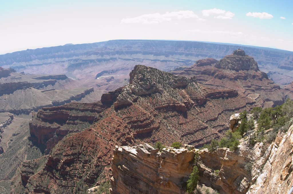 We relaxed for awhile on a bench at the rim of the canyon enjoying the view of the Angels Window. Another short stop to see the Walhalla Ruins, and we were on our way out of the Grand Canyon National Park.
 Back we went through the rolling green meadows of the Kaibab National Forest, and onto Route 89. Our next destination was Bryce Canyon National Park. We enjoyed the relatively short, very scenic drive, filled with greenery of the surrounding farms, and the shocking reds of the cliffs in the distance. We reached the town of Topic in a couple of hours. We were worried for a second when after crossing the town line, we saw no signs of civilization. However, in a minute or two we were driving through a cute little town, neat tiny houses on both sides of the road.
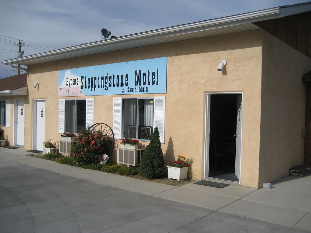 Again, we were a little worried when our hotel, the Stepping Stone Inn, turned out to be one of those tiny houses on the side of the road. The men went to check in, while Talia and I made a mad dash for the post office across the street. We were determined to make it at 4:56pm. Yet we forgot that we have crossed into a different time zone, so here in Topic it was really 5:56, and the post office has been close for almost an hour now.
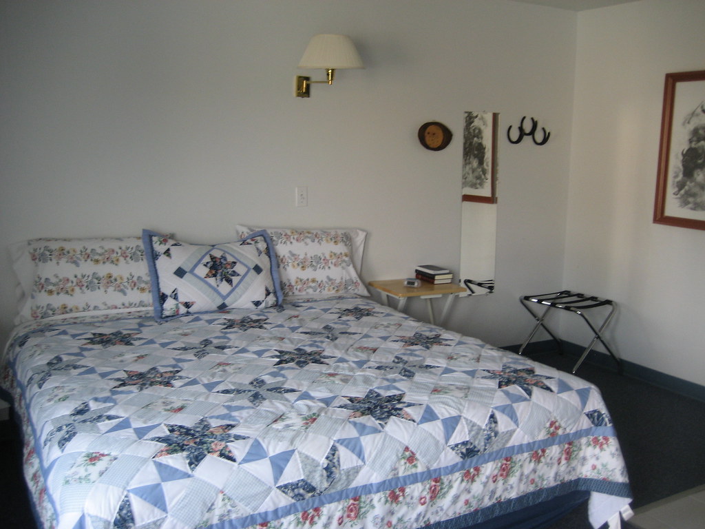 We did not need to be worried about the little Stepping Stone Inn. It was one of the cutest, cleanest hotels we stayed in, and especially unbeatable for the price. Our rooms were in the back, and each room exited directly outside. Cleaned to the shine, each room had a microwave, a good sized fridge, a hot pot, and the beds were covered with beautiful quilts. We were in love.
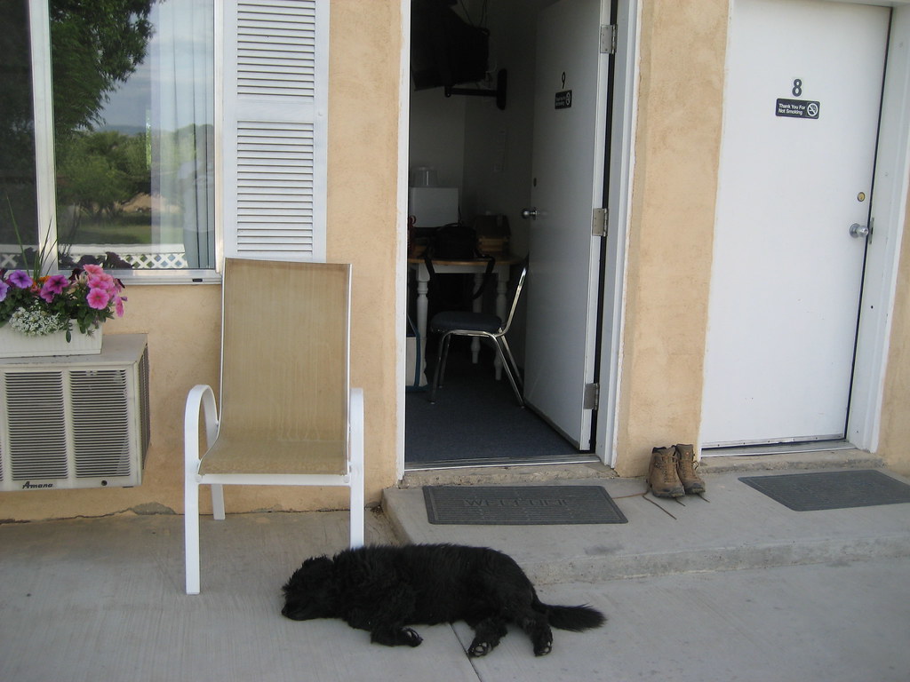 A shaggy black dog somewhat reminiscent of a cocker spaniel, was casually hanging out just outside our door ready to flop on its back and provide us with its belly for a good long rub. The dog was really laid back—it just laid there sleeping while I petted it, checked out its ears and even teeth. Thus it was so much more shocking, when this same dog sprung up on its four legs and ran out barking straight into the street as a large truck approached. I closed my eyes. The truck pulled in into the neighboring driveway, and everyone was fine. The truck was carrying 2 large dogs, who were calmly peering down at our fierce little friend. We thought he probably did this rather often since these dogs were his neighbors. Ryan called him a dog with a death wish…
We quickly repacked our cars such that we, together with some camping food and fire wood, could all fit into one car. The plan was to make a fire and have dinner at a picnic area in the park. We first drove to Inspiration Point of the Bryce Canyon National Park. Climbing up to the rim of the “canyon” from the parking lot we got our first glimpse of the hoodoos.
 Bryce Canyon is not really a canyon. Rather it is a very large amphitheater carved out by various erosion forces from the eastern rim of the Paunsaugunt Plateau, leaving a multitude of hoodoos behind. The word “hoodoo”, besides meaning “voodoo”, and “to cast a spell”, also means “a pillar of rock usually of fantastic shape, left by erosion.”
We made a stop at Bryce Point, and then drove out to Paria Point to watch the sunset. Unfortunately, the sunset was sabotaged by a few clouds covering the sun, though it did peak out for a few minutes right before falling behind the horizon.
It was now well after 8pm and we were debating over dinner as well as tomorrow’s hike. Nick was voted down in favor of getting up early and watching the sunrise with the hoodoos. (The word “hoodoo” got a lot of use during our times in the Bryce Canyon National Park.) Due to the planned early rise we scrambled our plans for a fire and a cook out tonight at the park. We drove back to our hotel where Talia prepared us a most nutritious meal of Trader Joe’s mac and cheese as well as some ramen.
Sunday, June 3, 2007
Grand Canyon: Kaibab Trail to the Roaring Springs
 I woke up a little after sunrise and felt surprisingly well rested. I say, “surprisingly”, because I don’t know who ever expects to sleep well while camping, unless of course you are so tired that it does not matter.
Before we fell asleep the night before, Nick promised today to be the hardest hike of our trip—the plan was to head down the North Kaibab trail to the Roaring Springs. The trail starts at the rim of the canyon and leads all the way down to the bottom almost six thousand feet below. The Roaring Springs is about three thousand feet below the rim and the hike is about five miles each way.
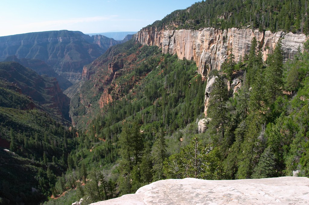 We started down the trail around 8. A little enclosure by the trail head held several mules, waiting to take people on a ride down into the canyon. The trail started among quaking aspens (as opposed to quacking aspens), and quickly led us to a view point on the ledge – Coconino Overlook. We could see our trail threading its way down the canyon far below. We were on top of a rock layer that looked very white with yellow and silver blue stripes running down its surface. As we continued down, we were soon brushing our shoulders against the red walls while the white rocks towered far above us.
 We crossed paths with mule processions several times. In fact the presence of mules on the trail was hard not to notice, their pee and poop, both fresh and dried, scattered everywhere. Apparently mules are not only stubborn, but also rather jumpy animals. The park rangers were constantly instructing us to be quiet and avoid making any sudden moves when in the presence of these big-eared creatures. They do look rather adorable with those droopy eyelids and long eye lashes.
 Less then two miles down the trail we reached a “rest stop” equipped with bathrooms and potable water. This also was a stop over for the mules—several of them were tied up near by. Continuing down the trail we had to walk through a little tunnel, though not too small, as it had to be big enough for the mules to pass.
At one point during our downward procession, Nick abruptly stopped us. We all listened. Everyone agreed that it sounded like a rock fall. We strained our eyes up and down the canyon walls in the direction of the sound. Nothing. A rock fall in this area could be worrisome for us as it might block the trail. Suddenly we noticed a group of mules below us. They were coming up a slight rise on the hill ahead after crossing a little bridge. The mules walking on the bridge and the echo of their horseshoes hitting the wood created the sounds we mistook for a rock fall.
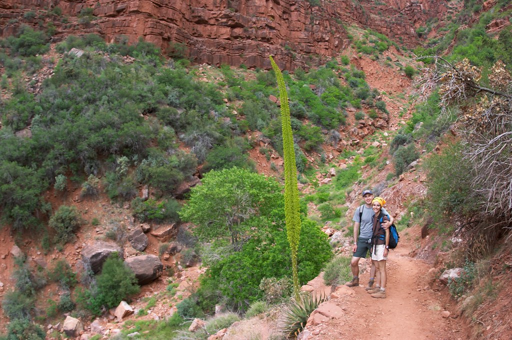 The trail towards the Roaring Springs led mostly downward except for a short section after crossing the bridge. We continued to cut across different types of sandstone, and the colors around us changed constantly. We had a friendly discussion about the plant with long thick leaves whose royal stock full of bright yellowish green flowers rose over 10 feet high. Some of us thought it was an aloe plant, while the others argued it was a yacca, or maybe even a yucca plant. A park ranger settled the dispute by announcing the plant to be from the agave family, meaning it was neither a yucca nor an aloe.
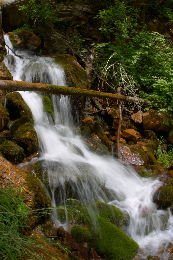 It took us about four and a half hours to reach the Roaring Springs. We could see the thin long waterfall as we approached, but once at the rest area, we could only hear the water, and enjoy the deep shade of the trees and tall grasses growing around us. The hike down was more tiring then I expected, and we took a nap after lunch while Nick wondered restlessly around.
I was very nervous about the hike back out of the canyon. Yet, unexpectedly it went blazingly fast. Perhaps it was because we took fewer photos on the way back. Or perhaps we were all a little tired, and eager to be done with the hike. We actually spent less time going up the trail back to the rim, than we did going down.
Back at the rest stop near the tunnel we saw 6 people who completely fit the profile of someone who, according to the park service, would most likely be in need of assistance out of the canyon.
 They were males in their early 20s, probably still in college. Young, buff, fit, they have been hiking since 3am that morning, and they started at the South Rim of the Grand Canyon. The trail leading from the South Rim down to the Colorado River and up to the North Rim is over 21 miles long and implies an elevation gain of about 6000 feet, while the temperatures at the lower parts of the canyon are brutally hot. Faced with a difficult trail and harsh conditions, these young men wore old sneakers, carried very small water bottles, and took off their shirts doubtlessly to achieve maximum exposure to the sun and the fastest dehydration rate. This time these guys made it out fine, though rather pink and tired. Normally the “rim to rim” trail is done over 3 day.
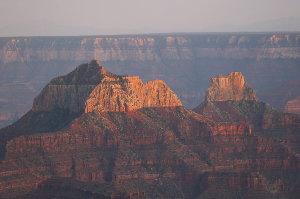 Back at our campsite, we went to wash off in coin operated showers. Famous for taking exceedingly long showers, I was granted 2 sets of quarters, and while I could have done away with one, I decided to indulge and used up the second set as well.
 Squeaky clean we again drove out to the Grand Canyon Lodge this time arriving right in time to watch the sunset. The canyon turned many shades of purple, while oranges and pinks of the setting sun played on the horizon. We crowned the evening with a fabulous meal at the restaurant in the Grand Canyon Lodge.
Subscribe to:
Posts (Atom)


