Saturday, June 2, 2007

Laundry and Our First Glimpse of the Grand Canyon

Another breakfast with the Germans, and we packed into the car and checked out of the hotel. We now should have been on our way to the North Rim of the Grand Canyon to meet our friend Ryan and his girlfriend Talia, who would be joining us in the adventures for this coming week. However, the laundromat called.

Saturday morning must be the prime time to do laundry because the laundromat was extremely crowded. Nick and I got a taste of being the minority. Everyone was Indian. Little kids were eyeing us with curiosity. People were mostly not speaking English, still increasing our sense of being in a foreign country.

Drying our clothes turned out to be trickier then we had foreseen. More then half of the dryers were out of order. Many people like us were looking for an empty dryer, yet there was no clear queue that we could detect. After running back and forth between lanes of machines, navigating between carts of clean, and dirty, and dry and wet laundry, and carefully avoiding little kids climbing the tables, we finally got a dryer. Nick struck a conversation with the only other white couple at the laundromat, and got to use their dryer as a consequence. They were an elderly couple from California who spent the previous two nights camping by a Navajo National Monument, Betatakin, which they could not stop raving about.

We finally started out on our way to the Grand Canyon around 11 am, with many pieces of not so dry laundry spread out over the back seat of the car. The drive was pretty. We descended down into a valley and went past the Vermilion Cliffs. We stopped for lunch in Page, AZ near Lake Powell, and stopped at the super secure Glen Canyon Damn over Colorado River. The road to the Grand Canyon National Park on the North Rim winds through the Kaibab National Forest. Its vast green meadows reminded us very much of Yellowstone National Park, except that the meadows there were yellow probably because we were there in September.

We checked into our camping site and found a deserted silver Honda Civic with “1 TALIA” license plate parked right next to it. Ryan and Talia were already here—now we just had to find them. Nick assumed that they must have started hiking down the nearby trail that led to the Grand Canyon Lodge and ended at the Bright Angel’s Point. We frantically ran down the trail for about 3 minutes when Nick abruptly stopped running. He decided, rightly so, that there is no point in catching up with them even if we could, and so we drove to the lodge instead.

The Grand Canyon LodgeThe Grand Canyon Lodge on the North Rim was first built in 1928, but burned down completely in 1932. The “new” Grand Canyon Lodge was built in 1937 on the footprint of the 1928 lodge thus using the same floor plan. Gilbert Stanley Underwood designed this rustic lodge such that visitors would not see the canyon when they first arrived and walked through the front entrance. Guests must make their way across the grand foyer, and descend a few steps into the “sun room.” It is here that they get their first glimpse of the Grand Canyon.

Our mouths ajar, we walked through the “sun room” and on to the terrace. By now we have seen many colorful rocks and formations, but the sheer magnitude of the Grand Canyon was unbelievable. Layers upon layers of purple, red, and grey rocks laid exposed while the unseen river flowed somewhere far below.
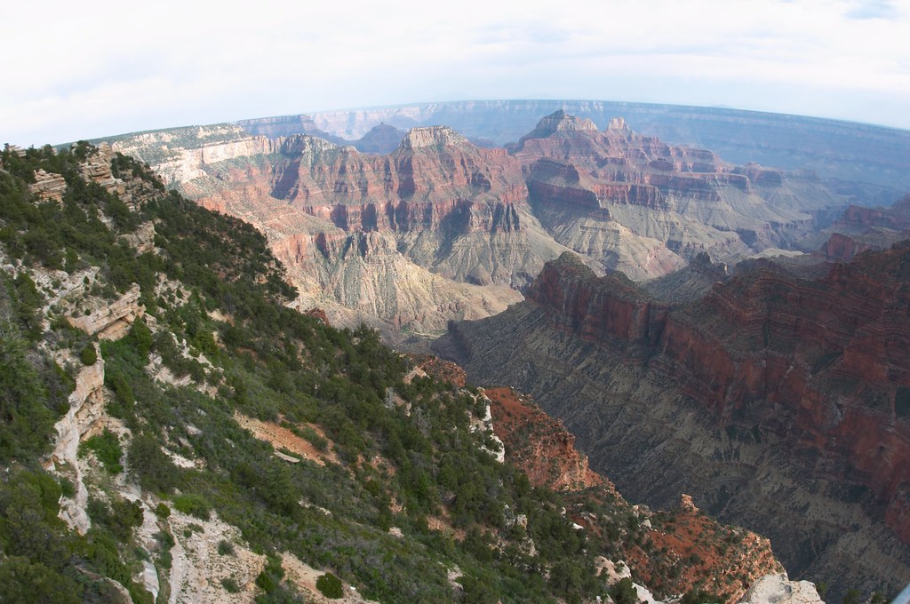
by Ryan ONick and I walked out to the Bright Angel’s Point. As we walked back along the canyon rim towards the lodge, we saw Ryan and Talia, who were about to take the trail back to the camping site. Instead we drove back together, eager to start our primitive living mode.

Talia and I set up the tents while the men went off to obtain a bottle of wine and firewood. Soon we had a nice fire going, and food was plentiful. By the time it was dark, we have feasted on hotdogs, cous-cous and some Trader Joe’s eggplant sauce and lentils.

When Nick and I camped together a few times before, I always found myself feeling a bit on edge after dark, afraid of everything I could not see, which would be … everything. However, tonight I felt no fear at all, which I attributed to the “power in numbers.”

Friday, June 1, 2007

Monument Valley

When we arrived to partake our lovely continental breakfast, Nick and I discovered that we were one of no more then 2 or 3 couples/families who spoke English in the dining room. Everyone else was speaking German. At first we thought maybe there were all in a group traveling with some bus tour. Yet there was no bus, and from eavesdropping on their conversations we determined that none of these people have ever met each other, and that they were from different towns in Germany.

We drove out to the Monument Valley Navajo Tribal Park again. Compared to last night, the park was very busy. Friendly Navajo men, dressed in cowboy attire, hailed us from their little booths trying to get us to go on a guided bus or ATV tour with them, or else go on a horse ride. A lot of RVs and motorcycles were parked in the lot. I suppose you might want to avoid driving an RV or a motorcycle on the scenic drive loop where the road is not paved and full of holes. We watched one rented RV—as the family got out and locked the car, two labs promptly took the driver and the passenger seats. Both dogs had that look of importance on them, and were ready for their ride, wondering why no one was taking them on one.

West MittenWe headed for our 3.5 mile hike around the West Mitten, which allowed us to get very close to the formation. Many of the rock formations, including the Mittens are shaped like a fin, meaning that they are very thin. We were the only hikers on the trail, our shoes took on the red color of the sand, and we felt as if we were all alone in the wilderness surrounded by the red rocks. The desert was still in its spring colors. Most of the grasses and shrubs were very green, and some even in bloom.

West Mitten in ProfileWe had lunch on the terrace of the visitor center. Again we were surrounded by Germans. These Germans, however, were all on motorcycles. Judging from the fact that a multitude of motorcycles in the parking lot were identical, the Germans must have rented them in the same place somewhere in US and then traveled to the Monument Valley. I cannot imagine these people traveled all the way to US only to see the Monument Valley, but Nick and I could not deduce where else they were traveling to since we definitely did not see such a concentration of Germans anywhere else we visited on this trip.

View from the Artists' PointAfter lunch we drove around the scenic loop again stopping at a few lookouts we skipped the night before because it was getting too dark. The sparse green shrubs merged together in the distance producing a variety of colors all contrasting with the stern redness of the rock formations. We have decided that the Monument Valley is truly monumental.

We got back on the main road, but drove away from Kayenta, following Route 163 marked as a scenic byway in our atlas. Various rock formations marched along the road. As we neared a little town called Mexican Hat, the cliffs on the right side of the road have become much lighter in color, but stricken with strands of darker reds and purples. They looked like something from an impressionist painting. As we were leaving the town, we saw the rock which must be responsible for the town’s name.

Mexican Hat


GoosenecksWe ended up driving to the Goosenecks State Park. A thousand feet below us the San Juan River was meandering back and forth for five miles while crossing only a mile of land. The silence together with the flatness and bareness of the ground around us made the site breath taking.

While driving along Route 163 we noticed many little wooden stands, sometimes with flags flying next to them. Last night they were empty, but today as we drove to the Monument Valley we saw some people there, laying out their goods. These little booths were trading stands the Navajo craftsmen use to sell their work to tourists like us. We stopped in a couple places as we drove back towards Kayenta.

The Three SistersAcross the road from the Monument Valley Navajo Tribal Park, there was a Navajo market -- a concentration of several booths in a row. Seeing many cars parked in front of the booths we decided to do our souvenir shopping there. Judging by the number of cars this was a good place to shop. As soon as we got there, we realized that we were one of only two couples currently shopping in this entire market. All the cars belonged to the people running the little stores.

Nevertheless we walked through all of them. It was extremely awkward to walk into the darkness of a little booth, being clearly a tourist. As we encountered more talkative tradesmen we became more talkative as well. It seemed like these people were pretty bored sitting in their booths by themselves with no potential buyers coming by. They wanted to talk even when they did not initiate the conversation. One lady with heavily painted eyebrows had a lovely little dog with her in the store. The dog promptly plopped onto the ground and presented me her round little tummy for scratching. Two ladies from two neighboring booths were chatting. One of them was bragging about her the new house she was building because the old one burned out. She was pointing out her new house to the other lady through the binoculars.

Some started telling us about a special 25% off sale today only—they really wanted us to buy something, as the business seemed very slow. I bought a little silver bracelet with a “sunrise” design and red corals from the lady with a new house. She said it was her husband who was the craftsman making all the jewelry in her store.

We grabbed fast food for dinner and headed back to our hotel for a quiet evening. We were planning to do laundry, but we were too late, so it would have to wait till tomorrow. We will be camping for the next two nights, so we would need some clean clothes for that.

Thursday, May 31, 2007

Four Corners

The morning was filled with searching for Nick’s camera charger, which was finally discovered under the front seat of the car, but only after every single item of our luggage was unpacked and repacked approximately 4 times. After enjoying the breakfast on our balcony, we checked out of our lovely room and headed out for a hike down the Spruce Canyon Trail.

Spruce Tree HouseThe Spruce Tree House was just a few hundreds yards down a steep but well maintained trail. These cliff dwellings were not as large as the ones at the Cliff Palace, but there was reconstructed kiva which Nick and I promptly climbed into. Darkness, sand in the air and the low ceiling created a rather claustrophobic atmosphere here. I could feel the sand in my mouth when we climbed back out.

A kiva is thought to have been a place of gathering for worship, and at least one can be found adjacent to most cliff dwellings and pithouses. Kivas were usually round, with the fire built in the middle of the room. The only way in and out was through a whole in the ceiling located directly above the fire. Thus anyone coming in or going out had to climb through the smoke. Each kiva also had another source of air for ventilation.

As we hiked down deeper into the Spruce Tree Canyon, we could tell we were getting closer to the water as progressively more bugs were attacking us right and left. At the lowest point of our hike the grass was growing tall and bright green all around the trail—a drastic change from the desert-like rim of the canyon. As we completed the loop and climbed out of the canyon we walked through a burned area of the mesa. Here most trees were bare and charred, and only small underbrush was green.

At the Far View RuinsWe made two more stops on our way out of the park. At the Far View Ruins, Nick and I climbed through a tiny door to look into a series of rooms built above ground and walked up the trail to see a dry reservoir.


Nick and the La Plata MountainsOur second stop was at Park Point. A walk through very young woods just springing up after a fire led us to the edge of the cliff and some spectacular views of the Montezuma Valley and the La Plata Mountains.


At the Four CornersThe Wal-Mart in Cortez, CO was the only place I could find 100 ISO film. On our way out of Colorado we could not help but stop at the Four Corners. It is a definite tourist trap, but entirely worth the $3 per person entrance fee to be able to stand in 4 states all at the same time. The states that meet up at the Four Corners are Colorado, New Mexico, Utah and Arizona.

Small houses mostly in need of serious repair were sparsely scattered by the road. The combination of being in a desert like environment and seeing these poor living conditions created a sense of being in a foreign country. It reminded me of Honduras a little bit. Yet we were still in the United States, driving through the Indian Reservation.

We checked into our hotel in Kayenta, AZ in the early evening, and without bothering to unload the car drove over 20 miles to get our first glimpse of the Monument Valley.

The MittensMonument Valley is located on the border of Utah and Arizona, and is part of the Indian Reservation. The sun was getting ready to set when we arrived. As we slowly drove along the 18 mile unpaved scenic loop, vibrant reds and bloody oranges played on the rocks. It was both amazing and sad to see people living right next to these magnificent rock formations. Colorful laundry hung out to dry seemed incongruent with the grandeur of the landscape.


Three Sisters Behind a Yucca PlantWe stopped at many viewpoints along the loop, which took us over 2 hours to drive. The shadows were purple when we reached the Artists Point, and the darkness set in when we completed the loop. As I looked back something enormous was shining bright gold on the horizon. For a second I thought it was an outrageously enormous billboard still reflecting the last rays of sunlight, but it was the moon. An enormous orange moon was quickly rising above the park.

Wednesday, May 30, 2007

Mesa Verde National Park

Late last night we arrived at the Mesa Verde National Park. Winding up the serpentine road towards the top of the mesa in complete darkness was beautiful and mysterious. The giant black cliffs reminded me of our arrival in the Badlands for the first time.

We were staying at the Far View Lodge inside the park and it was absolutely beautiful. Our room had a little balcony with a magnificent view including La Plata Mountains. The copper sink, stone floors, Navajo style décor all exuded charm and coziness. The room also provided us with a small refrigerator, a priceless accommodation during our road trip. The Far View area of the park is at the elevation of eight thousand feet, so it was breezy and pleasantly cool.


View from Our BalconyMesa Verde National Park is designated to preserve the works of the Anasazi people. The people have lived at Mesa Verde since about 600AD, but something forced them to start building their homes in the cliffs of the canyon around 1200. By 1300 the mesa, including the cliff dwellings, was completely abandoned. While there are many theories on the subject, what caused these people to build homes in hard to get to cliffs and then abandon them only a couple generations later remains to be a mystery.


Cliff PalaceWe started the day with a guided tour of the Cliff Palace. From the viewing platform at the top of the cliff, the structures looked like a miniature little town, little houses built one on top of another. A steep paved path snaked down the cliff. The early people had to use much more difficult approaches to their houses. Tower in the Cliff PalaceUp close the houses looked unusually well built. It was hard to believe that they were over 700 years old. The ranger leading our group offered his favorite theories to explain the mysteries of the cliff dwellings. I was surprised to learn that the houses originally were colorful and decorated with various patterns and paintings. We were able to see some examples of the painting on the inside walls of the tower. The way out of the Cliff Palace required climbing a series of 10-foot ladders.

After a brief break we headed for our guided tour of the Balcony House. The Balcony House was much harder to access than the Cliff Palace, requiring everyone to climb a 32-foot ladder.

Climbing into the Balcony HouseBefore taking us on the tour, the ranger spent more then a minute warning the group of the dangers involved in taking the tour with a heart condition and even described someone dieing on this tour. The ladder was indeed a bit intimidating, and I think it was nice that the park goes out of its way to warn the visitors of the risk. Balcony HouseOn one hand, I might argue that the warning was excessive when comparing this tour to some other hikes we did in other National Parks. On the other hand, the area of the tour is at elevation of over 6000 feet which does make any moving, hiking and especially climbing a lot more difficult.

Aside: Zion National Park should have a ranger stationed at all times at the Scout’s Lookout in Zion National Park warning people of the risks involved in climbing the trail to Angel’s Landing, and specifically relating the details of fatal incidents.

Through the Tunnel at the Balcony HouseThe Balcony House seemed like it would be even harder to get to then the Cliff Palace. A very narrow tunnel on the one side where the original entrance was would make the “house” an easily defensible place. We had to crawl through the tunnel on our way out.

Nick and I spent the afternoon driving around the Chapin Mesa stopping to look at some late pithouses and Pueblo ruins. Unfortunately we could not make it to the Wetherill Mesa because the road there was closed for repairs. After relaxing in our fabulous room and enjoying the view from the balcony, we headed to the Metate Room Restaurant at the Far View Lodge for a nice quite dinner. Tomorrow we will be heading to Monument Valley.

Tuesday, May 29, 2007

Moab, UT--Dinosaur Tracks

Our final adventure in Moab was the dinosaur tracks.

Raptor footprintThe Copper Ridge Sauropod Dinosaur Tracks site is about a mile drive along an unpaved road just north of Moab, UT. We had a little adventure finding the turn off the highway, but it is indeed very close.

Raptor tracksThe site did not seem to be too popular with the tourists. There must have been no more then 10 visitor groups who have signed the “guest book” in the last week. We walked about 100 yards up a trail and reached a sign describing the tracks, the dinosaurs and showing a photograph of one of the tracks at the site.

Sauropod tracksNick and I walked out to the rocks beyond the sign and began our search for the promised footprints. I did not really know what I was looking for, so I was more or less pointlessly wondering about looking at various shapes of the rock under my feet. Nick definitely had a purpose. He was diligently pouring water over different depressions in the rock hoping to see the dinosaur paw imprint. But to no avail. Half an hour later we were still walking staring at the same rocks looking for the tracks.

I decided to take a little more interest in finding the tracks because I sensed that we would not leave the place without seeing the dinosaur tracks, and the idea of spending the rest of the evening there did not appeal so much to me. Nick and I decided to concentrate on the photo displayed on the sign and to search for the rocks in the photo in order to identify the location of the tracks.

To make the long story short, the tracks were located in front of the sign, not beyond it where we were so diligently searching. In other words, the tracks would be behind a person reading the sign. We essentially walked right over them when we approached the sign.

SauropodThe sauropod tracks were enormous, but not so interesting in appearance because there was very little detail visible in the enormous holes in the ground. The raptor tracks, on the other hand, were fascinating. They clearly revealed the three separate “fingers” with claws at the end.

RaptorNick’s rejoicing over finding the tracks had no end. He photographed them from all angles possible. He poured water in them to make their shape clearly visible. He stood in the tracks. He lay next to the tracks. He had me photograph him in various poses next to the tracks. When the thorough documentation of our visit to the dinosaur track site was over, Nick and I left the tracks to dry out in the sun and drove south out of Moab. Tonight our destination was Mesa Verde National Park in Colorado.

Biking in Moab, Utah

We are leaving Moab today, but not before experiencing one of Moab’s biggest attractions—mountain biking. With two mountain bikes, rented from Poison Spider bike shop, in the trunk of our car we drove along the Colorado River lined by giant red sheets of rock and parked as soon as the pavement ended. There was only one other car parked in this rather large lot.

I admit I have not been on the bike in a few years. I do own a lovely yellow Gary Fischer mountain bike. Yes, I love my yellow bike. However, Nick and I have not gone biking since moving to Boston. We have many excuses—first not having a car, then being lazy about getting Nick’s bike fixed, not having a car again, etc… So when Nick suggested I try out my rented bike in the bike shop parking lot, I refused. Frankly I felt my knees starting to shake, and all the biker guys around definitely looked rather intimidating.

Now alone with Nick in this large rocky parking lot I mounted the bike with my knees still shaking. I did not forget how to ride the bike, but the thought of not only riding the bike, but also having to operate the breaks and the gears made the hairs on my back stand up.

SwitchbacksThe plan was to go to the Hurrah Pass. Nick and I started along the gravel road which ran slightly uphill along the cliff of the canyon. After a few turns, the road started sloping sharply downward descending into the canyon. My bike started gaining speed (with me on it). I did not feel in complete control of my bike in the first place, and now increasing speed, ever larger potholes in the road, tight switchbacks, and horrible noises the bike was making did not increase my confidence in my mountain biking abilities. A few seconds later and on the verge of tears I was walking my bike downhill through all those potholes, large rocks and switchbacks. As Minh used to say, “There is no shame in walking.”

Nick, who had to walk a little bit on the way up but passed me on the way down, was waiting for me at the bottom of the hill. As he handed me a bottle of Gatorade, he thoughtfully remarked that he has considered intermediate level biking trails but ended up choosing the Hurrah Pass trail because it was described as an easy trail suitable for families with little kids.

The rest of the ride towards the pass was much easier for me, and I think pure fun for Nick. I did discover that cow grates intended of course to keep cows out of the specific area also worked really well for keeping biking Helens out of the same areas. First time I came across one of these on my bike, I had to dismount and walk way around it. Luckily on the way back I was able to control my bike sufficiently so that I did not have to dismount, but I still slowly rode around the cow grate.

ClimbersWhile biking we noticed two climbers scaling a vertical wall of the canyon. For me the coolest part of that was noticing two labs wagging their tails waiting for their owner on the ledge below.

We decided not to attempt biking all the way to the Hurrah Pass as the last 2 miles to the pass were going to be a continuous uphill, and therefore not as much fun. Instead we turned off onto a branching trail towards a creek and had lunch under a poplar tree.

The ride back seemed easier and went by faster, probably because most of it was a little downhill. Repeating another one of Minh’s “mottos” to myself, “Speed is your friend” I was able to dismount fewer times on the way back. I am also proud to say that I rode up the hill that I walked down only stopping once to take a break.

Overall we rode a little more then 12 miles in about 3 hours. I think if Nick and I could be combined into one biker we would do pretty well. Nick would speed through all the downhills and various obstacles, while I would push through the uphills. Regardless we enjoyed the ride and the scenery.

Monday, May 28, 2007

Arches National Park, Windows and Fiery Furnace

We started our second day at the Arches National Park by heading to the Windows section. After hiking to the enormous Double Arch, we followed the trail past the Turret Arch and the North and South Window arches. The primitive access trail on our way back revealed different views of the North and South Window arches and beautiful vistas of the valley below and La Sal Mountains in the distance.

Turret Arch


The hike towards the Delicate ArchOur next adventure was the hike up to the Delicate Arch, one of the most popular hikes people do at the park. After a few switchbacks the trail led up a giant rock. From a distance the hikers looked like little ants climbing up this hill. Eventually the path leveled, and the Delicate Arch revealed itself just around the corner.

Delicate ArchThe best time to view the Delicate Arch is supposed to be at sunset, but even in the middle of the day when we got there it was a magnificent sight. Perched on the edge of a cliff, the arch turned out to be a lot bigger then I imagined it to be. Honestly I could not have imagined the real grandeur of many arches we saw without standing underneath them or seeing them in relation to people standing nearby. The enormity of these rock formations is hard to comprehend. The snow on the peaks of the La Sal Mountains shined in the distance behind the Delicate Arch.

Balanced RockAfter hiking to the Delicate Arch we took a break before a three hour and approximately 2.5 mile guided hike through the Fiery Furnace. We spent our time driving through the park, stopping at various pull outs to enjoy the views, and strolling around the Balanced Rock formation.

We decided to take a guided tour because the Fiery Furnace rocks form a maze of sorts that is very easy to get lost in. At 4 pm sharp we were standing at the Fiery Furnace viewpoint ready for our guided tour. We were part of a group of 25 people following a park ranger. On the hike we learned that apparently the mormon tea plant is of the ephedra family, and ring tail cats have been sighted regularly in the Devil’s Garden area of the park. The ranger also helped us through some of the more difficult parts of the trail.

CourthouseWith just a couple hours of light left, we hiked half way up the Park Avenue trail and returned to the Courthouse rock formation when the sun was almost gone. This sunset was our first and last in the park for now, and it was sad to leave. Despite all the crowds the rock formations felt inspirational. We will have to return here again one day. Park Avenue